Vendôme geodata
Vendôme (Centre) is a seat of a third-order administrative division; located in France in Europe/Paris (GMT+2) time zone. With population of 19,226 people, there are 477 cities with bigger population in this country. Compared to other cities in France, 55.6% of cities are located further ↓South; 68.2% of cities are located further →East and 69.2% of cities have higher elevation than Vendôme. Note1
Administrative division(s):
- Level 1: Centre
- Level 2: Département du Loir-et-Cher
- Level 3: Arrondissement de Vendôme
- Level 4: Vendôme


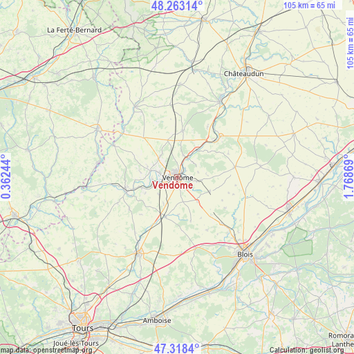
Vendôme GPS coordinates[2]
47° 47' 34.512" North, 1° 3' 56.016" East
| Map corner | latitude | longitude |
|---|---|---|
| Upper-left | 48.26314°, | 0.36244° |
| Center: | 47.79292°, | 1.06556° |
| Lower-right: | 47.3184°, | 1.76869° |
| Map W x H: | 105×105 km | = 65.2×65.2mi |
| max Lat: | 51.07786° ⇑44.4% North |
| Vendôme: | 47.79292° |
| min Lat: | ⇓55.6% South 41.3874° |
| min Long | Vendôme | max Long |
| -5.08615° | 1.06556° | 9.52242° |
| W 31.8%⇐ | ⇒68.2% E |
Elevation
Elevation of Vendôme is 80 m = 262 ft, and this is 113.7 m = 373 ft below average elevation for this country.
| Max E: |
2333 m = 7654 ft | 69.2% |
| Avg. | 193.7 m = 635 ft | |
| Vendôme | 80 m = 262 ft | |
Min E: |
-1 m = -3 ft | 30.8% |
See also: France elevation on elevation.city.
Geographical zone
Vendôme is located in North temperate zone (between Tropic of Cancer and the Arctic Circle). Distance of this North polar circle is 2087.1 km =1296.9 mi to North.| Distance of | km | miles | from Vendôme |
|---|---|---|---|
| North Pole | 4693 | 2916.1 | to North |
| Arctic Circle | 2087.1 | 1296.9 | to North |
| Tropic Cancer | 2708.2 | 1682.8 | to South |
| Equator | 5314.1 | 3302 | to South |


Nearby cities:
15 places around Vendôme: (largest is in red/bold)
• Areines
2.5 km =1.6 mi,  63°
63°
• Azé
8.2 km =5.1 mi,  322°
322°
• Danzé
11.7 km =7.3 mi,  345°
345°
• La Ville-aux-Clercs
14 km =8.7 mi,  6°
6°
• Lunay
11.4 km =7.1 mi,  278°
278°
• Mazangé
9.6 km =6 mi,  291°
291°
• Naveil
2.5 km =1.6 mi, 277°
• Pezou
10.1 km =6.3 mi,  34°
34°
• Saint-Amand-Longpré
12.7 km =7.9 mi,  196°
196°
• Saint-Firmin-des-Prés
6.5 km =4 mi, 34°
• Saint-Ouen
2.6 km =1.6 mi, 25°
• Selommes
10.4 km =6.5 mi,  113°
113°
• Thoré-la-Rochette
7.6 km =4.7 mi,  265°
265°
• Villerable
4.7 km =2.9 mi,  213°
213°
• Villiers-sur-Loir
5.2 km =3.2 mi, 284°
Sources, notices
• [Note1] Compared only with cities in France existing in our database
• [Src1] Map data: © OpenStreetMap contributors (CC-BY-SA)
• [Src2] Other city data from geonames.org with taken over terms of usage.
• [Src3] Geographical zone / Annual Mean Temperature by Robert A. Rohde @ Wikipedia
