Naveil geodata
Naveil (Centre) is a populated place; located in France in Europe/Paris (GMT+2) time zone. With population of 1,914 people, there are 5002 cities with bigger population in this country. Compared to other cities in France, 55.6% of cities are located further ↓South; 68.5% of cities are located further →East and 69.7% of cities have higher elevation than Naveil. Note1
Administrative division(s):
- Level 1: Centre
- Level 2: Département du Loir-et-Cher
- Level 3: Arrondissement de Vendôme
- Level 4: Naveil


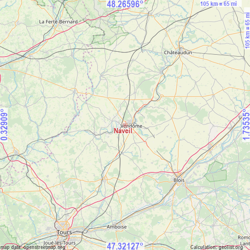
Naveil GPS coordinates[2]
47° 47' 44.736" North, 1° 1' 55.992" East
| Map corner | latitude | longitude |
|---|---|---|
| Upper-left | 48.26596°, | 0.32909° |
| Center: | 47.79576°, | 1.03222° |
| Lower-right: | 47.32127°, | 1.73535° |
| Map W x H: | 105×105 km | = 65.2×65.2mi |
| max Lat: | 51.07786° ⇑44.4% North |
| Naveil: | 47.79576° |
| min Lat: | ⇓55.6% South 41.3874° |
| min Long | Naveil | max Long |
| -5.08615° | 1.03222° | 9.52242° |
| W 31.5%⇐ | ⇒68.5% E |
Elevation
Elevation of Naveil is 79 m = 259 ft, and this is 114.7 m = 376 ft below average elevation for this country.
| Max E: |
2333 m = 7654 ft | 69.7% |
| Avg. | 193.7 m = 635 ft | |
| Naveil | 79 m = 259 ft | |
Min E: |
-1 m = -3 ft | 30.3% |
See also: France elevation on elevation.city.
Geographical zone
Naveil is located in North temperate zone (between Tropic of Cancer and the Arctic Circle). Distance of this North polar circle is 2086.8 km =1296.7 mi to North.| Distance of | km | miles | from Naveil |
|---|---|---|---|
| North Pole | 4692.7 | 2915.9 | to North |
| Arctic Circle | 2086.8 | 1296.7 | to North |
| Tropic Cancer | 2708.5 | 1683 | to South |
| Equator | 5314.4 | 3302.2 | to South |


Nearby cities:
15 places around Naveil: (largest is in red/bold)
• Areines
4.8 km =3 mi,  80°
80°
• Azé
6.7 km =4.2 mi,  337°
337°
• Danzé
11 km =6.8 mi,  357°
357°
• Lunay
8.9 km =5.5 mi,  279°
279°
• Mazangé
7.2 km =4.5 mi,  295°
295°
• Montoire-sur-le-Loir
13.3 km =8.3 mi,  249°
249°
• Pezou
11.5 km =7.1 mi,  46°
46°
• Saint-Amand-Longpré
12.6 km =7.8 mi,  185°
185°
• Saint-Firmin-des-Prés
8 km =5 mi, 50°
• Saint-Ouen
4.2 km =2.6 mi,  60°
60°
• Selommes
12.9 km =8 mi,  110°
110°
• Thoré-la-Rochette
5.2 km =3.2 mi,  259°
259°
• Vendôme
2.5 km =1.6 mi,  97°
97°
• Villerable
4.2 km =2.6 mi,  180°
180°
• Villiers-sur-Loir
2.8 km =1.7 mi,  291°
291°
Sources, notices
• [Note1] Compared only with cities in France existing in our database
• [Src1] Map data: © OpenStreetMap contributors (CC-BY-SA)
• [Src2] Other city data from geonames.org with taken over terms of usage.
• [Src3] Geographical zone / Annual Mean Temperature by Robert A. Rohde @ Wikipedia
