Triel-sur-Seine geodata
Triel-sur-Seine (Île-de-France) is a populated place; located in France in Europe/Paris (GMT+2) time zone. With population of 12,574 people, there are 757 cities with bigger population in this country. Compared to other cities in France, 79.2% of cities are located further ↓South; 57.1% of cities are located further →East and 81.5% of cities have higher elevation than Triel-sur-Seine. Note1
Administrative division(s):
- Level 1: Île-de-France
- Level 2: Yvelines
- Level 3: Arrondissement de Saint-Germain-en-Laye
- Level 4: Triel-sur-Seine


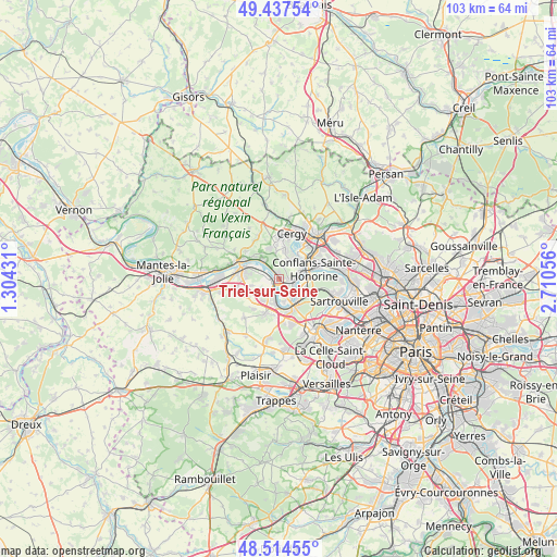
Triel-sur-Seine GPS coordinates[2]
48° 58' 41.448" North, 2° 0' 26.748" East
| Map corner | latitude | longitude |
|---|---|---|
| Upper-left | 49.43754°, | 1.30431° |
| Center: | 48.97818°, | 2.00743° |
| Lower-right: | 48.51455°, | 2.71056° |
| Map W x H: | 102.6×102.6 km | = 63.8×63.8mi |
| max Lat: | 51.07786° ⇑20.8% North |
| Triel-sur-Seine: | 48.97818° |
| min Lat: | ⇓79.2% South 41.3874° |
| min Long | Triel-sur-Seine | max Long |
| -5.08615° | 2.00743° | 9.52242° |
| W 42.9%⇐ | ⇒57.1% E |
Elevation
Elevation of Triel-sur-Seine is 51 m = 167 ft, and this is 142.7 m = 468 ft below average elevation for this country.
| Max E: |
2333 m = 7654 ft | 81.5% |
| Avg. | 193.7 m = 635 ft | |
| Triel-sur-Seine | 51 m = 167 ft | |
Min E: |
-1 m = -3 ft | 18.5% |
See also: France elevation on elevation.city.
Geographical zone
Triel-sur-Seine is located in North temperate zone (between Tropic of Cancer and the Arctic Circle). Distance of this North polar circle is 1955.3 km =1215 mi to North.| Distance of | km | miles | from Triel-sur-Seine |
|---|---|---|---|
| North Pole | 4561.2 | 2834.2 | to North |
| Arctic Circle | 1955.3 | 1215 | to North |
| Tropic Cancer | 2839.9 | 1764.6 | to South |
| Equator | 5445.9 | 3383.9 | to South |


Nearby cities:
15 places around Triel-sur-Seine: (largest is in red/bold)
• Achères
4.9 km =3 mi,  112°
112°
• Andrésy
3.6 km =2.2 mi,  82°
82°
• Boisemont
5.2 km =3.2 mi,  358°
358°
• Carrières-sous-Poissy
4 km =2.5 mi,  142°
142°
• Chanteloup-les-Vignes
1.9 km =1.2 mi,  97°
97°
• Chapet
5.6 km =3.5 mi,  256°
256°
• Jouy-le-Moutier
4.3 km =2.7 mi,  33°
33°
• Maurecourt
4.4 km =2.7 mi,  63°
63°
• Menucourt
5.9 km =3.7 mi,  340°
340°
• Médan
2.7 km =1.7 mi,  199°
199°
• Neuville-sur-Oise
6.1 km =3.8 mi,  45°
45°
• Vaux-sur-Seine
4.7 km =2.9 mi,  324°
324°
• Verneuil-sur-Seine
3.1 km =1.9 mi, 261°
• Vernouillet
2.1 km =1.3 mi,  248°
248°
• Villennes-sur-Seine
4.3 km =2.7 mi, 195°
Sources, notices
• [Note1] Compared only with cities in France existing in our database
• [Src1] Map data: © OpenStreetMap contributors (CC-BY-SA)
• [Src2] Other city data from geonames.org with taken over terms of usage.
• [Src3] Geographical zone / Annual Mean Temperature by Robert A. Rohde @ Wikipedia
