Vernouillet geodata
Vernouillet (Île-de-France) is a populated place; located in France in Europe/Paris (GMT+2) time zone. With population of 9,965 people, there are 956 cities with bigger population in this country. Compared to other cities in France, 79% of cities are located further ↓South; 57.4% of cities are located further →East and 81.1% of cities have higher elevation than Vernouillet. Note1
Administrative division(s):
- Level 1: Île-de-France
- Level 2: Yvelines
- Level 3: Arrondissement de Saint-Germain-en-Laye
- Level 4: Vernouillet


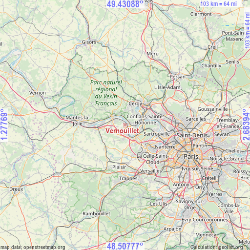
Vernouillet GPS coordinates[2]
48° 58' 17.256" North, 1° 58' 50.952" East
| Map corner | latitude | longitude |
|---|---|---|
| Upper-left | 49.43088°, | 1.27769° |
| Center: | 48.97146°, | 1.98082° |
| Lower-right: | 48.50777°, | 2.68394° |
| Map W x H: | 102.6×102.6 km | = 63.8×63.8mi |
| max Lat: | 51.07786° ⇑21% North |
| Vernouillet: | 48.97146° |
| min Lat: | ⇓79% South 41.3874° |
| min Long | Vernouillet | max Long |
| -5.08615° | 1.98082° | 9.52242° |
| W 42.6%⇐ | ⇒57.4% E |
Elevation
Elevation of Vernouillet is 52 m = 171 ft, and this is 141.7 m = 465 ft below average elevation for this country.
| Max E: |
2333 m = 7654 ft | 81.1% |
| Avg. | 193.7 m = 635 ft | |
| Vernouillet | 52 m = 171 ft | |
Min E: |
-1 m = -3 ft | 18.9% |
See also: France elevation on elevation.city.
Geographical zone
Vernouillet is located in North temperate zone (between Tropic of Cancer and the Arctic Circle). Distance of this North polar circle is 1956.1 km =1215.5 mi to North.| Distance of | km | miles | from Vernouillet |
|---|---|---|---|
| North Pole | 4561.9 | 2834.6 | to North |
| Arctic Circle | 1956.1 | 1215.5 | to North |
| Tropic Cancer | 2839.2 | 1764.2 | to South |
| Equator | 5445.1 | 3383.4 | to South |


Nearby cities:
15 places around Vernouillet: (largest is in red/bold)
• Andrésy
5.7 km =3.5 mi,  77°
77°
• Bouafle
5.9 km =3.7 mi,  262°
262°
• Carrières-sous-Poissy
5 km =3.1 mi,  119°
119°
• Chanteloup-les-Vignes
3.8 km =2.4 mi, 82°
• Chapet
3.5 km =2.2 mi, 261°
• Ecquevilly
4.7 km =2.9 mi,  242°
242°
• Les Mureaux
5.7 km =3.5 mi,  293°
293°
• Morainvilliers
5.7 km =3.5 mi,  214°
214°
• Médan
2.1 km =1.3 mi,  150°
150°
• Orgeval
5.5 km =3.4 mi,  182°
182°
• Triel-sur-Seine
2.1 km =1.3 mi,  68°
68°
• Vaux-sur-Seine
4.7 km =2.9 mi,  349°
349°
• Verneuil-sur-Seine
1.2 km =0.7 mi,  282°
282°
• Villennes-sur-Seine
3.4 km =2.1 mi,  167°
167°
• Évecquemont
5.5 km =3.4 mi,  330°
330°
Sources, notices
• [Note1] Compared only with cities in France existing in our database
• [Src1] Map data: © OpenStreetMap contributors (CC-BY-SA)
• [Src2] Other city data from geonames.org with taken over terms of usage.
• [Src3] Geographical zone / Annual Mean Temperature by Robert A. Rohde @ Wikipedia
