Vaunaveys-la-Rochette geodata
Vaunaveys-la-Rochette (Auvergne-Rhône-Alpes) is a populated place; located in France in Europe/Paris (GMT+2) time zone. With population of 587 people, there are 13526 cities with bigger population in this country. Compared to other cities in France, 81.6% of cities are located further ↑North; 78% of cities are located further ←West and 77.4% of cities have lower elevation than Vaunaveys-la-Rochette. Note1
Administrative division(s):
- Level 1: Auvergne-Rhône-Alpes
- Level 2: Département de la Drôme
- Level 3: Arrondissement de Die
- Level 4: Vaunaveys-la-Rochette
Current local time in Vaunaveys-la-Rochette:
05:29 PM, SaturdayDifference from your time zone: hours


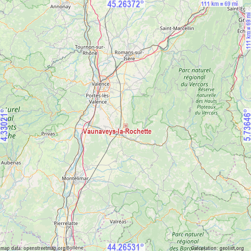
Vaunaveys-la-Rochette GPS coordinates[2]
44° 46' 0.012" North, 5° 1' 59.988" East
| Map corner | latitude | longitude |
|---|---|---|
| Upper-left | 45.26372°, | 4.33021° |
| Center: | 44.76667°, | 5.03333° |
| Lower-right: | 44.26531°, | 5.73646° |
| Map W x H: | 111×111 km | = 69×69mi |
| max Lat: | 51.07786° ⇑81.6% North |
| Vaunaveys-la-Rochette: | 44.76667° |
| min Lat: | ⇓18.4% South 41.3874° |
| min Long | Vaunaveys-la-Ro | max Long |
| -5.08615° | 5.03333° | 9.52242° |
| W 78%⇐ | ⇒22% E |
Elevation
Elevation of Vaunaveys-la-Rochette is 267 m = 876 ft, and this is 73.3 m = 240 ft above average elevation for this country.
| Max E: |
2333 m = 7654 ft | 22.6% |
| Vaunaveys-la-Rochette | 267 m 876 ft | |
| Avg. | 193.7 m = 635 ft | |
Min E: |
-1 m = -3 ft | 77.4% |
See also: France elevation on elevation.city.
Geographical zone
Vaunaveys-la-Rochette is located in North temperate zone (between Tropic of Cancer and the Arctic Circle). Distance of this Northern Tropic circle is 2371.7 km =1473.7 mi to South.| Distance of | km | miles | from Vaunaveys-la-Rochette |
|---|---|---|---|
| North Pole | 5029.5 | 3125.2 | to North |
| Arctic Circle | 2423.6 | 1506 | to North |
| Tropic Cancer | 2371.7 | 1473.7 | to South |
| Equator | 4977.6 | 3092.9 | to South |


Nearby cities:
15 places around Vaunaveys-la-Rochette: (largest is in red/bold)
• Allex
10.7 km =6.6 mi,  270°
270°
• Aouste-sur-Sye
5.6 km =3.5 mi,  163°
163°
• Beaumont-lès-Valence
12.8 km =8 mi,  326°
326°
• Chabrillan
8.8 km =5.5 mi,  236°
236°
• Crest
4.7 km =2.9 mi,  197°
197°
• Eurre
3.7 km =2.3 mi,  255°
255°
• Grane
9.6 km =6 mi,  246°
246°
• Haut Divajeu
7.1 km =4.4 mi,  190°
190°
• Mirabel-et-Blacons
8.3 km =5.2 mi,  135°
135°
• Montmeyran
8.9 km =5.5 mi, 327°
• Montoison
8 km =5 mi,  294°
294°
• Montvendre
11.6 km =7.2 mi,  356°
356°
• Montéléger
12.3 km =7.6 mi,  321°
321°
• Piégros-la-Clastre
10.9 km =6.8 mi,  151°
151°
• Upie
6 km =3.7 mi,  311°
311°
Sources, notices
• [Note1] Compared only with cities in France existing in our database
• [Src1] Map data: © OpenStreetMap contributors (CC-BY-SA)
• [Src2] Other city data from geonames.org with taken over terms of usage.
• [Src3] Geographical zone / Annual Mean Temperature by Robert A. Rohde @ Wikipedia
