Upie geodata
Upie (Auvergne-Rhône-Alpes) is a populated place; located in France in Europe/Paris (GMT+2) time zone. With population of 1,239 people, there are 7334 cities with bigger population in this country. Compared to other cities in France, 81.4% of cities are located further ↑North; 77.4% of cities are located further ←West and 70.9% of cities have lower elevation than Upie. Note1
Administrative division(s):
- Level 1: Auvergne-Rhône-Alpes
- Level 2: Département de la Drôme
- Level 3: Arrondissement de Valence
- Level 4: Upie


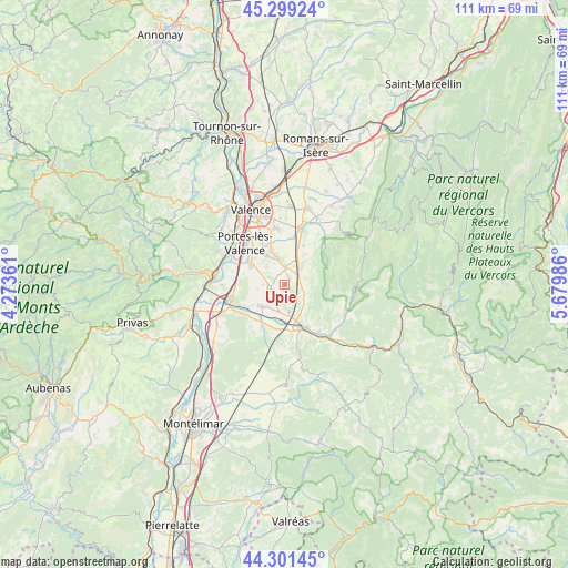
Upie GPS coordinates[2]
44° 48' 9" North, 4° 58' 36.228" East
| Map corner | latitude | longitude |
|---|---|---|
| Upper-left | 45.29924°, | 4.27361° |
| Center: | 44.8025°, | 4.97673° |
| Lower-right: | 44.30145°, | 5.67986° |
| Map W x H: | 110.9×110.9 km | = 68.9×68.9mi |
| max Lat: | 51.07786° ⇑81.4% North |
| Upie: | 44.8025° |
| min Lat: | ⇓18.6% South 41.3874° |
| min Long | Upie | max Long |
| -5.08615° | 4.97673° | 9.52242° |
| W 77.4%⇐ | ⇒22.6% E |
Elevation
Elevation of Upie is 223 m = 732 ft, and this is 29.3 m = 96 ft above average elevation for this country.
| Max E: |
2333 m = 7654 ft | 29.1% |
| Upie | 223 m 732 ft | |
| Avg. | 193.7 m = 635 ft | |
Min E: |
-1 m = -3 ft | 70.9% |
See also: France elevation on elevation.city.
Geographical zone
Upie is located in North temperate zone (between Tropic of Cancer and the Arctic Circle). Distance of this Northern Tropic circle is 2375.7 km =1476.2 mi to South.| Distance of | km | miles | from Upie |
|---|---|---|---|
| North Pole | 5025.5 | 3122.7 | to North |
| Arctic Circle | 2419.6 | 1503.5 | to North |
| Tropic Cancer | 2375.7 | 1476.2 | to South |
| Equator | 4981.6 | 3095.4 | to South |


Nearby cities:
15 places around Upie: (largest is in red/bold)
• Allex
7.3 km =4.5 mi,  237°
237°
• Beaumont-lès-Valence
7.1 km =4.4 mi,  338°
338°
• Beauvallon
8.1 km =5 mi,  317°
317°
• Chabrillan
9.3 km =5.8 mi,  198°
198°
• Crest
9 km =5.6 mi,  160°
160°
• Eurre
5 km =3.1 mi,  169°
169°
• Grane
8.9 km =5.5 mi,  209°
209°
• Livron-sur-Drôme
11 km =6.8 mi,  255°
255°
• Malissard
11 km =6.8 mi,  350°
350°
• Montmeyran
3.5 km =2.2 mi, 353°
• Montoison
2.9 km =1.8 mi, 255°
• Montvendre
8.5 km =5.3 mi,  26°
26°
• Montéléger
6.5 km =4 mi,  330°
330°
• Vaunaveys-la-Rochette
6 km =3.7 mi,  131°
131°
• Étoile-sur-Rhône
7.9 km =4.9 mi,  300°
300°
Sources, notices
• [Note1] Compared only with cities in France existing in our database
• [Src1] Map data: © OpenStreetMap contributors (CC-BY-SA)
• [Src2] Other city data from geonames.org with taken over terms of usage.
• [Src3] Geographical zone / Annual Mean Temperature by Robert A. Rohde @ Wikipedia
