Allex geodata
Allex (Auvergne-Rhône-Alpes) is a populated place; located in France in Europe/Paris (GMT+2) time zone. With population of 2,245 people, there are 4286 cities with bigger population in this country. Compared to other cities in France, 81.6% of cities are located further ↑North; 76.5% of cities are located further ←West and 55% of cities have lower elevation than Allex. Note1
Administrative division(s):
- Level 1: Auvergne-Rhône-Alpes
- Level 2: Département de la Drôme
- Level 3: Arrondissement de Die
- Level 4: Allex


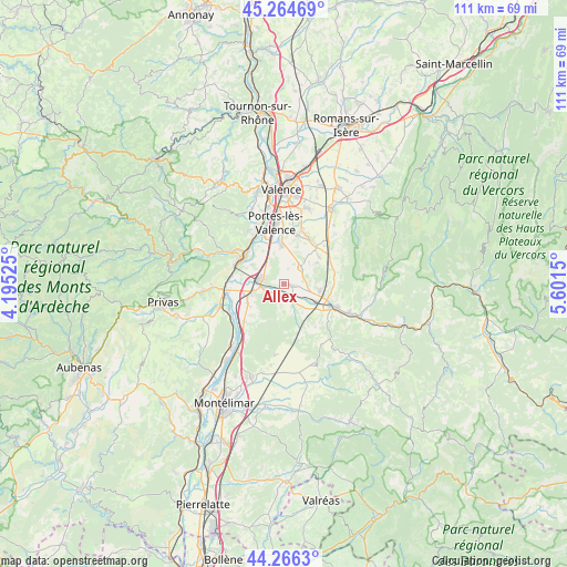
Allex GPS coordinates[2]
44° 46' 3.54" North, 4° 53' 54.132" East
| Map corner | latitude | longitude |
|---|---|---|
| Upper-left | 45.26469°, | 4.19525° |
| Center: | 44.76765°, | 4.89837° |
| Lower-right: | 44.2663°, | 5.6015° |
| Map W x H: | 111×111 km | = 69×69mi |
| max Lat: | 51.07786° ⇑81.6% North |
| Allex: | 44.76765° |
| min Lat: | ⇓18.4% South 41.3874° |
| min Long | Allex | max Long |
| -5.08615° | 4.89837° | 9.52242° |
| W 76.5%⇐ | ⇒23.5% E |
Elevation
Elevation of Allex is 150 m = 492 ft, and this is 43.7 m = 143 ft below average elevation for this country.
| Max E: |
2333 m = 7654 ft | 45% |
| Avg. | 193.7 m = 635 ft | |
| Allex | 150 m = 492 ft | |
Min E: |
-1 m = -3 ft | 55% |
See also: France elevation on elevation.city.
Geographical zone
Allex is located in North temperate zone (between Tropic of Cancer and the Arctic Circle). Distance of this Northern Tropic circle is 2371.8 km =1473.8 mi to South.| Distance of | km | miles | from Allex |
|---|---|---|---|
| North Pole | 5029.4 | 3125.1 | to North |
| Arctic Circle | 2423.5 | 1505.9 | to North |
| Tropic Cancer | 2371.8 | 1473.8 | to South |
| Equator | 4977.7 | 3093 | to South |


Nearby cities:
15 places around Allex: (largest is in red/bold)
• Beauchastel
9.9 km =6.2 mi,  310°
310°
• Beauvallon
9.8 km =6.1 mi,  4°
4°
• Chabrillan
6 km =3.7 mi,  146°
146°
• Cliousclat
7.7 km =4.8 mi,  222°
222°
• Eurre
7.2 km =4.5 mi,  98°
98°
• Grane
4.3 km =2.7 mi, 154°
• La Voulte-sur-Rhône
10 km =6.2 mi,  290°
290°
• Livron-sur-Drôme
4.6 km =2.9 mi,  282°
282°
• Loriol-sur-Drôme
6.8 km =4.2 mi,  250°
250°
• Mirmande
9.1 km =5.7 mi,  213°
213°
• Montmeyran
9.4 km =5.8 mi,  38°
38°
• Montoison
4.6 km =2.9 mi,  46°
46°
• Montéléger
9.9 km =6.2 mi,  17°
17°
• Upie
7.3 km =4.5 mi,  57°
57°
• Étoile-sur-Rhône
7.9 km =4.9 mi,  355°
355°
Sources, notices
• [Note1] Compared only with cities in France existing in our database
• [Src1] Map data: © OpenStreetMap contributors (CC-BY-SA)
• [Src2] Other city data from geonames.org with taken over terms of usage.
• [Src3] Geographical zone / Annual Mean Temperature by Robert A. Rohde @ Wikipedia
