Tonnay-Boutonne geodata
Tonnay-Boutonne (Nouvelle-Aquitaine) is a populated place; located in France in Europe/Paris (GMT+2) time zone. With population of 1,217 people, there are 7448 cities with bigger population in this country. Compared to other cities in France, 66.6% of cities are located further ↑North; 85.6% of cities are located further →East and 95% of cities have higher elevation than Tonnay-Boutonne. Note1
Administrative division(s):
- Level 1: Nouvelle-Aquitaine
- Level 2: Charente-Maritime
- Level 3: Arrondissement de Saint-Jean-d'Angély
- Level 4: Tonnay-Boutonne


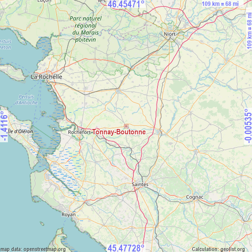
Tonnay-Boutonne GPS coordinates[2]
45° 58' 5.34" North, 0° 42' 30.492" West
| Map corner | latitude | longitude |
|---|---|---|
| Upper-left | 46.45471°, | -1.4116° |
| Center: | 45.96815°, | -0.70847° |
| Lower-right: | 45.47728°, | -0.00535° |
| Map W x H: | 108.7×108.7 km | = 67.5×67.5mi |
| max Lat: | 51.07786° ⇑66.6% North |
| Tonnay-Boutonne: | 45.96815° |
| min Lat: | ⇓33.4% South 41.3874° |
| min Long | Tonnay-Boutonne | max Long |
| -5.08615° | -0.70847° | 9.52242° |
| W 14.4%⇐ | ⇒85.6% E |
Elevation
Elevation of Tonnay-Boutonne is 17 m = 56 ft, and this is 176.7 m = 580 ft below average elevation for this country.
| Max E: |
2333 m = 7654 ft | 95% |
| Avg. | 193.7 m = 635 ft | |
| Tonnay-Boutonne | 17 m = 56 ft | |
Min E: |
-1 m = -3 ft | 5% |
See also: France elevation on elevation.city.
Geographical zone
Tonnay-Boutonne is located in North temperate zone (between Tropic of Cancer and the Arctic Circle). Distance of this North polar circle is 2290 km =1422.9 mi to North.| Distance of | km | miles | from Tonnay-Boutonne |
|---|---|---|---|
| North Pole | 4895.9 | 3042.2 | to North |
| Arctic Circle | 2290 | 1422.9 | to North |
| Tropic Cancer | 2505.3 | 1556.7 | to South |
| Equator | 5111.2 | 3176 | to South |


Nearby cities:
15 places around Tonnay-Boutonne: (largest is in red/bold)
• Archingeay
4 km =2.5 mi,  176°
176°
• Bernay-Saint-Martin
13 km =8.1 mi,  32°
32°
• Bords
10.4 km =6.5 mi,  220°
220°
• Cabariot
12.4 km =7.7 mi,  248°
248°
• Geay
11.6 km =7.2 mi,  201°
201°
• Genouillé
8.4 km =5.2 mi,  315°
315°
• La Vergne
11.1 km =6.9 mi,  91°
91°
• Landes
9 km =5.6 mi,  72°
72°
• Les Nouillers
5.3 km =3.3 mi,  139°
139°
• Lussant
9 km =5.6 mi,  264°
264°
• Mazeray
13.1 km =8.1 mi,  120°
120°
• Muron
11.9 km =7.4 mi,  308°
308°
• Romegoux
13 km =8.1 mi,  214°
214°
• Saint-Savinien
10.4 km =6.5 mi,  167°
167°
• Vandré
10.7 km =6.6 mi,  336°
336°
Sources, notices
• [Note1] Compared only with cities in France existing in our database
• [Src1] Map data: © OpenStreetMap contributors (CC-BY-SA)
• [Src2] Other city data from geonames.org with taken over terms of usage.
• [Src3] Geographical zone / Annual Mean Temperature by Robert A. Rohde @ Wikipedia
