Vallon-en-Sully geodata
Vallon-en-Sully (Auvergne-Rhône-Alpes) is a populated place; located in France in Europe/Paris (GMT+2) time zone. With population of 1,754 people, there are 5402 cities with bigger population in this country. Compared to other cities in France, 59.8% of cities are located further ↑North; 52.2% of cities are located further ←West and 62.7% of cities have lower elevation than Vallon-en-Sully. Note1
Administrative division(s):
- Level 1: Auvergne-Rhône-Alpes
- Level 2: Département de l'Allier
- Level 3: Arrondissement de Montluçon
- Level 4: Vallon-en-Sully


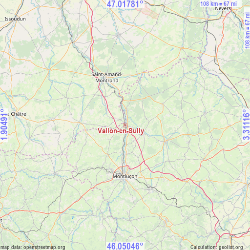
Vallon-en-Sully GPS coordinates[2]
46° 32' 10.644" North, 2° 36' 28.944" East
| Map corner | latitude | longitude |
|---|---|---|
| Upper-left | 47.01781°, | 1.90491° |
| Center: | 46.53629°, | 2.60804° |
| Lower-right: | 46.05046°, | 3.31116° |
| Map W x H: | 107.6×107.6 km | = 66.9×66.9mi |
| max Lat: | 51.07786° ⇑59.8% North |
| Vallon-en-Sully: | 46.53629° |
| min Lat: | ⇓40.2% South 41.3874° |
| min Long | Vallon-en-Sully | max Long |
| -5.08615° | 2.60804° | 9.52242° |
| W 52.2%⇐ | ⇒47.8% E |
Elevation
Elevation of Vallon-en-Sully is 183 m = 600 ft, and this is 10.7 m = 35 ft below average elevation for this country.
| Max E: |
2333 m = 7654 ft | 37.3% |
| Avg. | 193.7 m = 635 ft | |
| Vallon-en-Sully | 183 m = 600 ft | |
Min E: |
-1 m = -3 ft | 62.7% |
See also: France elevation on elevation.city.
Geographical zone
Vallon-en-Sully is located in North temperate zone (between Tropic of Cancer and the Arctic Circle). Distance of this North polar circle is 2226.8 km =1383.7 mi to North.| Distance of | km | miles | from Vallon-en-Sully |
|---|---|---|---|
| North Pole | 4832.7 | 3002.9 | to North |
| Arctic Circle | 2226.8 | 1383.7 | to North |
| Tropic Cancer | 2568.4 | 1595.9 | to South |
| Equator | 5174.4 | 3215.2 | to South |


Nearby cities:
15 places around Vallon-en-Sully: (largest is in red/bold)
• Ainay-le-Château
20.5 km =12.7 mi,  18°
18°
• Culan
19.8 km =12.3 mi,  273°
273°
• Cérilly
18.6 km =11.6 mi,  60°
60°
• Domérat
20.4 km =12.7 mi,  196°
196°
• Drevant
18.6 km =11.6 mi,  340°
340°
• Désertines
20.2 km =12.6 mi,  177°
177°
• Estivareilles
12.4 km =7.7 mi, 176°
• Huriel
20.8 km =12.9 mi,  208°
208°
• Hérisson
8.5 km =5.3 mi,  111°
111°
• La Chapelaude
15.2 km =9.4 mi, 211°
• Meaulne
6.9 km =4.3 mi,  4°
4°
• Saint-Bonnet-Tronçais
15.2 km =9.4 mi,  25°
25°
• Saint-Victor
15.7 km =9.8 mi, 179°
• Verneix
16.2 km =10.1 mi,  162°
162°
• Vesdun
13.7 km =8.5 mi, 271°
Sources, notices
• [Note1] Compared only with cities in France existing in our database
• [Src1] Map data: © OpenStreetMap contributors (CC-BY-SA)
• [Src2] Other city data from geonames.org with taken over terms of usage.
• [Src3] Geographical zone / Annual Mean Temperature by Robert A. Rohde @ Wikipedia
