Culan geodata
Culan (Centre) is a populated place; located in France in Europe/Paris (GMT+2) time zone. With population of 832 people, there are 10268 cities with bigger population in this country. Compared to other cities in France, 59.7% of cities are located further ↑North; 51.9% of cities are located further →East and 77.8% of cities have lower elevation than Culan. Note1
Administrative division(s):
- Level 1: Centre
- Level 2: Cher
- Level 3: Arrondissement de Saint-Amand-Montrond
- Level 4: Culan


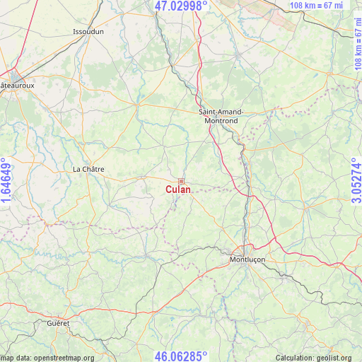
Culan GPS coordinates[2]
46° 32' 54.852" North, 2° 20' 58.632" East
| Map corner | latitude | longitude |
|---|---|---|
| Upper-left | 47.02998°, | 1.64649° |
| Center: | 46.54857°, | 2.34962° |
| Lower-right: | 46.06285°, | 3.05274° |
| Map W x H: | 107.5×107.5 km | = 66.8×66.8mi |
| max Lat: | 51.07786° ⇑59.7% North |
| Culan: | 46.54857° |
| min Lat: | ⇓40.3% South 41.3874° |
| min Long | Culan | max Long |
| -5.08615° | 2.34962° | 9.52242° |
| W 48.1%⇐ | ⇒51.9% E |
Elevation
Elevation of Culan is 270 m = 886 ft, and this is 76.3 m = 250 ft above average elevation for this country.
| Max E: |
2333 m = 7654 ft | 22.2% |
| Culan | 270 m 886 ft | |
| Avg. | 193.7 m = 635 ft | |
Min E: |
-1 m = -3 ft | 77.8% |
See also: France elevation on elevation.city.
Geographical zone
Culan is located in North temperate zone (between Tropic of Cancer and the Arctic Circle). Distance of this North polar circle is 2225.5 km =1382.9 mi to North.| Distance of | km | miles | from Culan |
|---|---|---|---|
| North Pole | 4831.3 | 3002 | to North |
| Arctic Circle | 2225.5 | 1382.9 | to North |
| Tropic Cancer | 2569.8 | 1596.8 | to South |
| Equator | 5175.7 | 3216 | to South |


Nearby cities:
15 places around Culan: (largest is in red/bold)
• Boussac
24.4 km =15.2 mi,  203°
203°
• Boussac-Bourg
22.7 km =14.1 mi, 202°
• Châteaumeillant
11.9 km =7.4 mi,  277°
277°
• Drevant
20.9 km =13 mi,  39°
39°
• Huriel
21.8 km =13.5 mi,  153°
153°
• La Chapelaude
18.6 km =11.6 mi,  140°
140°
• Le Châtelet
11.6 km =7.2 mi,  333°
333°
• Meaulne
21 km =13 mi,  74°
74°
• Orval
21.8 km =13.5 mi,  25°
25°
• Préveranges
14.8 km =9.2 mi,  209°
209°
• Saint-Amand-Montrond
22.7 km =14.1 mi, 31°
• Saint-Hilaire-en-Lignières
23.9 km =14.9 mi, 325°
• Sainte-Sévère-sur-Indre
22.4 km =13.9 mi,  252°
252°
• Vallon-en-Sully
19.8 km =12.3 mi,  93°
93°
• Vesdun
6.1 km =3.8 mi,  99°
99°
Sources, notices
• [Note1] Compared only with cities in France existing in our database
• [Src1] Map data: © OpenStreetMap contributors (CC-BY-SA)
• [Src2] Other city data from geonames.org with taken over terms of usage.
• [Src3] Geographical zone / Annual Mean Temperature by Robert A. Rohde @ Wikipedia
