Cérilly geodata
Cérilly (Auvergne-Rhône-Alpes) is a populated place; located in France in Europe/Paris (GMT+2) time zone. With population of 1,597 people, there are 5841 cities with bigger population in this country. Compared to other cities in France, 59.1% of cities are located further ↑North; 55.3% of cities are located further ←West and 83.9% of cities have lower elevation than Cérilly. Note1
Administrative division(s):
- Level 1: Auvergne-Rhône-Alpes
- Level 2: Département de l'Allier
- Level 3: Arrondissement de Montluçon
- Level 4: Cérilly


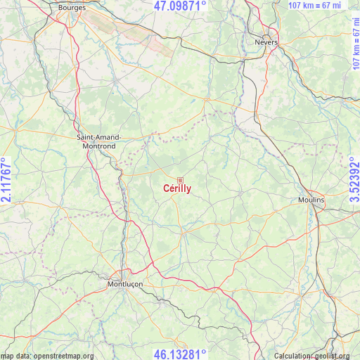
Cérilly GPS coordinates[2]
46° 37' 4.476" North, 2° 49' 14.88" East
| Map corner | latitude | longitude |
|---|---|---|
| Upper-left | 47.09871°, | 2.11767° |
| Center: | 46.61791°, | 2.8208° |
| Lower-right: | 46.13281°, | 3.52392° |
| Map W x H: | 107.4×107.4 km | = 66.7×66.7mi |
| max Lat: | 51.07786° ⇑59.1% North |
| Cérilly: | 46.61791° |
| min Lat: | ⇓40.9% South 41.3874° |
| min Long | Cérilly | max Long |
| -5.08615° | 2.8208° | 9.52242° |
| W 55.3%⇐ | ⇒44.7% E |
Elevation
Elevation of Cérilly is 333 m = 1093 ft, and this is 139.3 m = 457 ft above average elevation for this country.
| Max E: |
2333 m = 7654 ft | 16.1% |
| Cérilly | 333 m 1093 ft | |
| Avg. | 193.7 m = 635 ft | |
Min E: |
-1 m = -3 ft | 83.9% |
See also: France elevation on elevation.city.
Geographical zone
Cérilly is located in North temperate zone (between Tropic of Cancer and the Arctic Circle). Distance of this North polar circle is 2217.7 km =1378 mi to North.| Distance of | km | miles | from Cérilly |
|---|---|---|---|
| North Pole | 4823.6 | 2997.2 | to North |
| Arctic Circle | 2217.7 | 1378 | to North |
| Tropic Cancer | 2577.5 | 1601.6 | to South |
| Equator | 5183.4 | 3220.8 | to South |


Nearby cities:
15 places around Cérilly: (largest is in red/bold)
• Ainay-le-Château
14.3 km =8.9 mi,  316°
316°
• Bourbon-l’Archambault
18.4 km =11.4 mi,  102°
102°
• Buxières-les-Mines
19.8 km =12.3 mi,  147°
147°
• Charenton-du-Cher
18.3 km =11.4 mi,  312°
312°
• Couleuvre
9 km =5.6 mi,  47°
47°
• Drevant
24.1 km =15 mi,  290°
290°
• Hérisson
14.8 km =9.2 mi,  214°
214°
• Le Veurdre
22.7 km =14.1 mi, 47°
• Lurcy-Lévis
15.3 km =9.5 mi,  35°
35°
• Meaulne
15.9 km =9.9 mi,  262°
262°
• Saint-Bonnet-Tronçais
10.8 km =6.7 mi,  295°
295°
• Saint-Hilaire
20.5 km =12.7 mi,  132°
132°
• Saint-Pierre-les-Étieux
19.9 km =12.4 mi, 310°
• Vallon-en-Sully
18.6 km =11.6 mi,  240°
240°
• Ygrande
11.9 km =7.4 mi, 127°
Sources, notices
• [Note1] Compared only with cities in France existing in our database
• [Src1] Map data: © OpenStreetMap contributors (CC-BY-SA)
• [Src2] Other city data from geonames.org with taken over terms of usage.
• [Src3] Geographical zone / Annual Mean Temperature by Robert A. Rohde @ Wikipedia
