Vallière geodata
Vallière (Nouvelle-Aquitaine) is a populated place; located in France in Europe/Paris (GMT+2) time zone. With population of 782 people, there are 10798 cities with bigger population in this country. Compared to other cities in France, 62.8% of cities are located further ↑North; 50.3% of cities are located further →East and 89.9% of cities have lower elevation than Vallière. Note1
Administrative division(s):
- Level 1: Nouvelle-Aquitaine
- Level 2: Creuse
- Level 3: Aubusson
- Level 4: Vallière


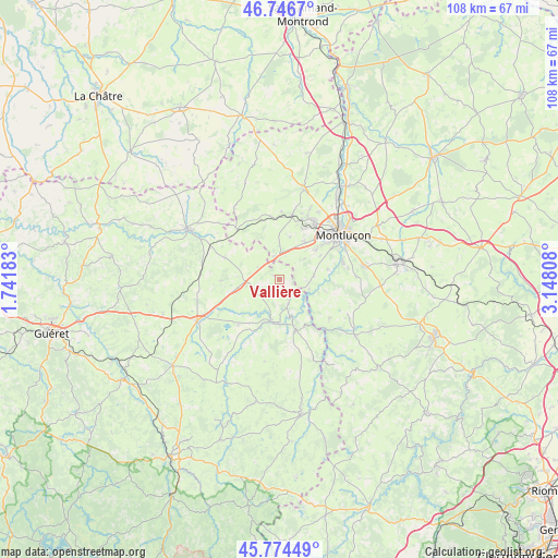
Vallière GPS coordinates[2]
46° 15' 45.9" North, 2° 26' 41.82" East
| Map corner | latitude | longitude |
|---|---|---|
| Upper-left | 46.7467°, | 1.74183° |
| Center: | 46.26275°, | 2.44495° |
| Lower-right: | 45.77449°, | 3.14808° |
| Map W x H: | 108.1×108.1 km | = 67.2×67.2mi |
| max Lat: | 51.07786° ⇑62.8% North |
| Vallière: | 46.26275° |
| min Lat: | ⇓37.2% South 41.3874° |
| min Long | Vallière | max Long |
| -5.08615° | 2.44495° | 9.52242° |
| W 49.7%⇐ | ⇒50.3% E |
Elevation
Elevation of Vallière is 424 m = 1391 ft, and this is 230.3 m = 756 ft above average elevation for this country.
| Max E: |
2333 m = 7654 ft | 10.1% |
| Vallière | 424 m 1391 ft | |
| Avg. | 193.7 m = 635 ft | |
Min E: |
-1 m = -3 ft | 89.9% |
See also: France elevation on elevation.city.
Geographical zone
Vallière is located in North temperate zone (between Tropic of Cancer and the Arctic Circle). Distance of this North polar circle is 2257.2 km =1402.6 mi to North.| Distance of | km | miles | from Vallière |
|---|---|---|---|
| North Pole | 4863.1 | 3021.8 | to North |
| Arctic Circle | 2257.2 | 1402.6 | to North |
| Tropic Cancer | 2538 | 1577 | to South |
| Equator | 5143.9 | 3196.3 | to South |


Nearby cities:
15 places around Vallière: (largest is in red/bold)
• Budelière
5 km =3.1 mi,  159°
159°
• Chambon-sur-Voueize
8.2 km =5.1 mi,  190°
190°
• Domérat
12.9 km =8 mi,  32°
32°
• Désertines
16.8 km =10.4 mi,  52°
52°
• Huriel
12.5 km =7.8 mi,  11°
11°
• Lavault-Sainte-Anne
13 km =8.1 mi,  66°
66°
• Lignerolles
9.5 km =5.9 mi,  78°
78°
• Montluçon
14.9 km =9.3 mi, 54°
• Néris-les-Bains
16.6 km =10.3 mi, 80°
• Prémilhat
9 km =5.6 mi, 51°
• Quinssaines
8.8 km =5.5 mi,  35°
35°
• Saint-Martinien
8.4 km =5.2 mi, 13°
• Soumans
11.5 km =7.1 mi,  291°
291°
• Villebret
14.9 km =9.3 mi,  88°
88°
• Évaux-les-Bains
10.3 km =6.4 mi, 162°
Sources, notices
• [Note1] Compared only with cities in France existing in our database
• [Src1] Map data: © OpenStreetMap contributors (CC-BY-SA)
• [Src2] Other city data from geonames.org with taken over terms of usage.
• [Src3] Geographical zone / Annual Mean Temperature by Robert A. Rohde @ Wikipedia
