Valenciennes geodata
Valenciennes (Hauts-de-France) is a seat of a third-order administrative division; located in France in Europe/Paris (GMT+2) time zone. With population of 44,821 people, there are 151 cities with bigger population in this country. Compared to other cities in France, 96.1% of cities are located further ↓South; 64.5% of cities are located further ←West and 89.5% of cities have higher elevation than Valenciennes. Note1
Administrative division(s):
- Level 1: Hauts-de-France
- Level 2: Nord
- Level 3: Arrondissement de Valenciennes
- Level 4: Valenciennes


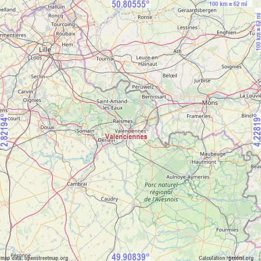
Valenciennes GPS coordinates[2]
50° 21' 32.724" North, 3° 31' 30.216" East
| Map corner | latitude | longitude |
|---|---|---|
| Upper-left | 50.80555°, | 2.82194° |
| Center: | 50.35909°, | 3.52506° |
| Lower-right: | 49.90839°, | 4.22819° |
| Map W x H: | 99.8×99.8 km | = 62×62mi |
| max Lat: | 51.07786° ⇑3.9% North |
| Valenciennes: | 50.35909° |
| min Lat: | ⇓96.1% South 41.3874° |
| min Long | Valenciennes | max Long |
| -5.08615° | 3.52506° | 9.52242° |
| W 64.5%⇐ | ⇒35.5% E |
Elevation
Elevation of Valenciennes is 31 m = 102 ft, and this is 162.7 m = 534 ft below average elevation for this country.
| Max E: |
2333 m = 7654 ft | 89.5% |
| Avg. | 193.7 m = 635 ft | |
| Valenciennes | 31 m = 102 ft | |
Min E: |
-1 m = -3 ft | 10.5% |
See also: Valenciennes elevation on elevation.city.
Geographical zone
Valenciennes is located in North temperate zone (between Tropic of Cancer and the Arctic Circle). Distance of this North polar circle is 1801.8 km =1119.6 mi to North.| Distance of | km | miles | from Valenciennes |
|---|---|---|---|
| North Pole | 4407.7 | 2738.8 | to North |
| Arctic Circle | 1801.8 | 1119.6 | to North |
| Tropic Cancer | 2993.5 | 1860.1 | to South |
| Equator | 5599.4 | 3479.3 | to South |


Nearby cities:
15 places around Valenciennes: (largest is in red/bold)
• Anzin
2.1 km =1.3 mi,  313°
313°
• Aubry-du-Hainaut
4.2 km =2.6 mi,  281°
281°
• Aulnoy-lez-Valenciennes
2.9 km =1.8 mi,  168°
168°
• Beuvrages
3.5 km =2.2 mi,  321°
321°
• Bruay-sur-l’Escaut
4.7 km =2.9 mi,  16°
16°
• Estreux
5 km =3.1 mi,  100°
100°
• Famars
4.6 km =2.9 mi,  184°
184°
• Hérin
5.1 km =3.2 mi,  265°
265°
• La Sentinelle
3 km =1.9 mi,  253°
253°
• Marly
2.3 km =1.4 mi,  130°
130°
• Petite-Forêt
3.1 km =1.9 mi,  285°
285°
• Raismes
4 km =2.5 mi, 312°
• Saint-Saulve
2.6 km =1.6 mi,  58°
58°
• Saultain
4.5 km =2.8 mi,  123°
123°
• Trith-Saint-Léger
5.6 km =3.5 mi,  212°
212°
Sources, notices
• [Note1] Compared only with cities in France existing in our database
• [Src1] Map data: © OpenStreetMap contributors (CC-BY-SA)
• [Src2] Other city data from geonames.org with taken over terms of usage.
• [Src3] Geographical zone / Annual Mean Temperature by Robert A. Rohde @ Wikipedia
