Raismes geodata
Raismes (Hauts-de-France) is a populated place; located in France in Europe/Paris (GMT+2) time zone. With population of 13,719 people, there are 694 cities with bigger population in this country. Compared to other cities in France, 96.3% of cities are located further ↓South; 64.1% of cities are located further ←West and 88.6% of cities have higher elevation than Raismes. Note1
Administrative division(s):
- Level 1: Hauts-de-France
- Level 2: Nord
- Level 3: Arrondissement de Valenciennes
- Level 4: Raismes


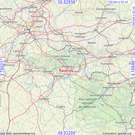
Raismes GPS coordinates[2]
50° 22' 59.988" North, 3° 28' 59.988" East
| Map corner | latitude | longitude |
|---|---|---|
| Upper-left | 50.82956°, | 2.78021° |
| Center: | 50.38333°, | 3.48333° |
| Lower-right: | 49.93286°, | 4.18646° |
| Map W x H: | 99.7×99.7 km | = 62×62mi |
| max Lat: | 51.07786° ⇑3.7% North |
| Raismes: | 50.38333° |
| min Lat: | ⇓96.3% South 41.3874° |
| min Long | Raismes | max Long |
| -5.08615° | 3.48333° | 9.52242° |
| W 64.1%⇐ | ⇒35.9% E |
Elevation
Elevation of Raismes is 33 m = 108 ft, and this is 160.7 m = 527 ft below average elevation for this country.
| Max E: |
2333 m = 7654 ft | 88.6% |
| Avg. | 193.7 m = 635 ft | |
| Raismes | 33 m = 108 ft | |
Min E: |
-1 m = -3 ft | 11.4% |
See also: France elevation on elevation.city.
Geographical zone
Raismes is located in North temperate zone (between Tropic of Cancer and the Arctic Circle). Distance of this North polar circle is 1799.1 km =1117.9 mi to North.| Distance of | km | miles | from Raismes |
|---|---|---|---|
| North Pole | 4405 | 2737.1 | to North |
| Arctic Circle | 1799.1 | 1117.9 | to North |
| Tropic Cancer | 2996.2 | 1861.8 | to South |
| Equator | 5602.1 | 3481 | to South |


Nearby cities:
15 places around Raismes: (largest is in red/bold)
• Anzin
1.9 km =1.2 mi,  130°
130°
• Aubry-du-Hainaut
2.2 km =1.4 mi,  212°
212°
• Aulnoy-lez-Valenciennes
6.6 km =4.1 mi,  147°
147°
• Bellaing
4.5 km =2.8 mi,  247°
247°
• Beuvrages
0.8 km =0.5 mi,  83°
83°
• Bruay-sur-l’Escaut
4.6 km =2.9 mi,  67°
67°
• Escautpont
6.3 km =3.9 mi,  51°
51°
• Haveluy
6.6 km =4.1 mi,  239°
239°
• Hérin
3.8 km =2.4 mi, 214°
• La Sentinelle
3.6 km =2.2 mi,  178°
178°
• Marly
6.3 km =3.9 mi, 131°
• Petite-Forêt
1.9 km =1.2 mi, 180°
• Saint-Saulve
5.3 km =3.3 mi,  104°
104°
• Valenciennes
4 km =2.5 mi, 132°
• Wallers
6.6 km =4.1 mi,  261°
261°
Sources, notices
• [Note1] Compared only with cities in France existing in our database
• [Src1] Map data: © OpenStreetMap contributors (CC-BY-SA)
• [Src2] Other city data from geonames.org with taken over terms of usage.
• [Src3] Geographical zone / Annual Mean Temperature by Robert A. Rohde @ Wikipedia
