Hérin geodata
Hérin (Hauts-de-France) is a populated place; located in France in Europe/Paris (GMT+2) time zone. With population of 4,025 people, there are 2440 cities with bigger population in this country. Compared to other cities in France, 96% of cities are located further ↓South; 63.8% of cities are located further ←West and 83.8% of cities have higher elevation than Hérin. Note1
Administrative division(s):
- Level 1: Hauts-de-France
- Level 2: Nord
- Level 3: Arrondissement de Valenciennes
- Level 4: Hérin


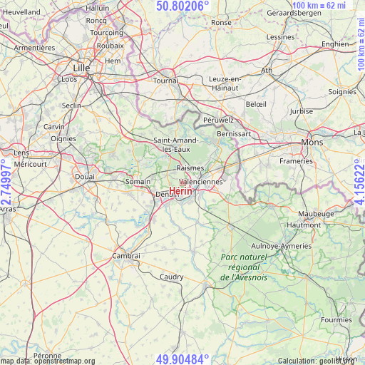
Hérin GPS coordinates[2]
50° 21' 20.052" North, 3° 27' 11.124" East
| Map corner | latitude | longitude |
|---|---|---|
| Upper-left | 50.80206°, | 2.74997° |
| Center: | 50.35557°, | 3.45309° |
| Lower-right: | 49.90484°, | 4.15622° |
| Map W x H: | 99.8×99.8 km | = 62×62mi |
| max Lat: | 51.07786° ⇑4% North |
| Hérin: | 50.35557° |
| min Lat: | ⇓96% South 41.3874° |
| min Long | Hérin | max Long |
| -5.08615° | 3.45309° | 9.52242° |
| W 63.8%⇐ | ⇒36.2% E |
Elevation
Elevation of Hérin is 45 m = 148 ft, and this is 148.7 m = 488 ft below average elevation for this country.
| Max E: |
2333 m = 7654 ft | 83.8% |
| Avg. | 193.7 m = 635 ft | |
| Hérin | 45 m = 148 ft | |
Min E: |
-1 m = -3 ft | 16.2% |
See also: France elevation on elevation.city.
Geographical zone
Hérin is located in North temperate zone (between Tropic of Cancer and the Arctic Circle). Distance of this North polar circle is 1802.2 km =1119.8 mi to North.| Distance of | km | miles | from Hérin |
|---|---|---|---|
| North Pole | 4408 | 2739 | to North |
| Arctic Circle | 1802.2 | 1119.8 | to North |
| Tropic Cancer | 2993.1 | 1859.8 | to South |
| Equator | 5599 | 3479.1 | to South |


Nearby cities:
15 places around Hérin: (largest is in red/bold)
• Anzin
4 km =2.5 mi,  63°
63°
• Aubry-du-Hainaut
1.6 km =1 mi,  37°
37°
• Bellaing
2.4 km =1.5 mi,  305°
305°
• Beuvrages
4.3 km =2.7 mi, 42°
• Haulchin
4.4 km =2.7 mi,  195°
195°
• Haveluy
3.5 km =2.2 mi,  265°
265°
• La Sentinelle
2.3 km =1.4 mi,  102°
102°
• Petite-Forêt
2.5 km =1.6 mi, 60°
• Prouvy
4.2 km =2.6 mi,  182°
182°
• Raismes
3.8 km =2.4 mi,  34°
34°
• Rouvignies
3.7 km =2.3 mi,  186°
186°
• Trith-Saint-Léger
4.8 km =3 mi,  153°
153°
• Valenciennes
5.1 km =3.2 mi,  85°
85°
• Wallers
4.8 km =3 mi,  295°
295°
• Wavrechain-sous-Denain
3.9 km =2.4 mi,  227°
227°
Sources, notices
• [Note1] Compared only with cities in France existing in our database
• [Src1] Map data: © OpenStreetMap contributors (CC-BY-SA)
• [Src2] Other city data from geonames.org with taken over terms of usage.
• [Src3] Geographical zone / Annual Mean Temperature by Robert A. Rohde @ Wikipedia
