Vaivre-et-Montoille geodata
Vaivre-et-Montoille (Bourgogne-Franche-Comté) is a populated place; located in France in Europe/Paris (GMT+2) time zone. With population of 2,423 people, there are 3993 cities with bigger population in this country. Compared to other cities in France, 53.1% of cities are located further ↓South; 88.2% of cities are located further ←West and 71.6% of cities have lower elevation than Vaivre-et-Montoille. Note1
Administrative division(s):
- Level 1: Bourgogne-Franche-Comté
- Level 2: Département de la Haute-Saône
- Level 3: Arrondissement de Vesoul
- Level 4: Vaivre-et-Montoille


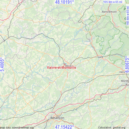
Vaivre-et-Montoille GPS coordinates[2]
47° 37' 48.756" North, 6° 6' 13.032" East
| Map corner | latitude | longitude |
|---|---|---|
| Upper-left | 48.10191°, | 5.4005° |
| Center: | 47.63021°, | 6.10362° |
| Lower-right: | 47.15422°, | 6.80675° |
| Map W x H: | 105.4×105.4 km | = 65.5×65.5mi |
| max Lat: | 51.07786° ⇑46.9% North |
| Vaivre-et-Montoille: | 47.63021° |
| min Lat: | ⇓53.1% South 41.3874° |
| min Long | Vaivre-et-Monto | max Long |
| -5.08615° | 6.10362° | 9.52242° |
| W 88.2%⇐ | ⇒11.8% E |
Elevation
Elevation of Vaivre-et-Montoille is 227 m = 745 ft, and this is 33.3 m = 109 ft above average elevation for this country.
| Max E: |
2333 m = 7654 ft | 28.4% |
| Vaivre-et-Montoille | 227 m 745 ft | |
| Avg. | 193.7 m = 635 ft | |
Min E: |
-1 m = -3 ft | 71.6% |
See also: France elevation on elevation.city.
Geographical zone
Vaivre-et-Montoille is located in North temperate zone (between Tropic of Cancer and the Arctic Circle). Distance of this North polar circle is 2105.2 km =1308.1 mi to North.| Distance of | km | miles | from Vaivre-et-Montoille |
|---|---|---|---|
| North Pole | 4711.1 | 2927.3 | to North |
| Arctic Circle | 2105.2 | 1308.1 | to North |
| Tropic Cancer | 2690.1 | 1671.6 | to South |
| Equator | 5296 | 3290.8 | to South |


Nearby cities:
15 places around Vaivre-et-Montoille: (largest is in red/bold)
• Breurey-lès-Faverney
14.1 km =8.8 mi,  8°
8°
• Faverney
15.2 km =9.4 mi,  0°
0°
• Frotey-lès-Vesoul
6.4 km =4 mi,  99°
99°
• Mailley-et-Chazelot
10.9 km =6.8 mi,  200°
200°
• Montigny-lès-Vesoul
2.5 km =1.6 mi,  290°
290°
• Navenne
5 km =3.1 mi,  118°
118°
• Noidans-le-Ferroux
13 km =8.1 mi,  239°
239°
• Noidans-lès-Vesoul
2.5 km =1.6 mi,  139°
139°
• Port-sur-Saône
7.5 km =4.7 mi,  327°
327°
• Pusey
3 km =1.9 mi,  34°
34°
• Quincey
6.5 km =4 mi,  108°
108°
• Scey-sur-Saône-et-Saint-Albin
10.4 km =6.5 mi, 291°
• Vesoul
3 km =1.9 mi, 99°
• Villers-le-Sec
9.4 km =5.8 mi, 111°
• Échenoz-la-Méline
4 km =2.5 mi, 143°
Sources, notices
• [Note1] Compared only with cities in France existing in our database
• [Src1] Map data: © OpenStreetMap contributors (CC-BY-SA)
• [Src2] Other city data from geonames.org with taken over terms of usage.
• [Src3] Geographical zone / Annual Mean Temperature by Robert A. Rohde @ Wikipedia
