Breurey-lès-Faverney geodata
Breurey-lès-Faverney (Bourgogne-Franche-Comté) is a populated place; located in France in Europe/Paris (GMT+2) time zone. With population of 525 people, there are 14719 cities with bigger population in this country. Compared to other cities in France, 55.1% of cities are located further ↓South; 88.6% of cities are located further ←West and 72% of cities have lower elevation than Breurey-lès-Faverney. Note1
Administrative division(s):
- Level 1: Bourgogne-Franche-Comté
- Level 2: Département de la Haute-Saône
- Level 3: Arrondissement de Vesoul
- Level 4: Breurey-lès-Faverney


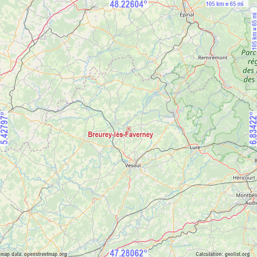
Breurey-lès-Faverney GPS coordinates[2]
47° 45' 19.728" North, 6° 7' 51.924" East
| Map corner | latitude | longitude |
|---|---|---|
| Upper-left | 48.22604°, | 5.42797° |
| Center: | 47.75548°, | 6.13109° |
| Lower-right: | 47.28062°, | 6.83422° |
| Map W x H: | 105.1×105.1 km | = 65.3×65.3mi |
| max Lat: | 51.07786° ⇑44.9% North |
| Breurey-lès-Faverney: | 47.75548° |
| min Lat: | ⇓55.1% South 41.3874° |
| min Long | Breurey-lès-Fa | max Long |
| -5.08615° | 6.13109° | 9.52242° |
| W 88.6%⇐ | ⇒11.4% E |
Elevation
Elevation of Breurey-lès-Faverney is 230 m = 755 ft, and this is 36.3 m = 119 ft above average elevation for this country.
| Max E: |
2333 m = 7654 ft | 28% |
| Breurey-lès-Faverney | 230 m 755 ft | |
| Avg. | 193.7 m = 635 ft | |
Min E: |
-1 m = -3 ft | 72% |
See also: France elevation on elevation.city.
Geographical zone
Breurey-lès-Faverney is located in North temperate zone (between Tropic of Cancer and the Arctic Circle). Distance of this North polar circle is 2091.3 km =1299.5 mi to North.| Distance of | km | miles | from Breurey-lès-Faverney |
|---|---|---|---|
| North Pole | 4697.2 | 2918.7 | to North |
| Arctic Circle | 2091.3 | 1299.5 | to North |
| Tropic Cancer | 2704 | 1680.2 | to South |
| Equator | 5309.9 | 3299.4 | to South |


Nearby cities:
15 places around Breurey-lès-Faverney: (largest is in red/bold)
• Amance
7.4 km =4.6 mi,  313°
313°
• Breuches
15.5 km =9.6 mi,  71°
71°
• Conflans-sur-Lanterne
9.3 km =5.8 mi,  43°
43°
• Faverney
2.4 km =1.5 mi,  302°
302°
• Frotey-lès-Vesoul
15.6 km =9.7 mi,  164°
164°
• Montigny-lès-Vesoul
13.8 km =8.6 mi,  198°
198°
• Noidans-lès-Vesoul
15.8 km =9.8 mi,  181°
181°
• Polaincourt-et-Clairefontaine
14.8 km =9.2 mi,  341°
341°
• Port-sur-Saône
9.7 km =6 mi,  218°
218°
• Pusey
11.5 km =7.1 mi, 181°
• Saint-Remy
9 km =5.6 mi, 344°
• Saulx
13 km =8.1 mi,  118°
118°
• Scey-sur-Saône-et-Saint-Albin
15.5 km =9.6 mi,  229°
229°
• Vaivre-et-Montoille
14.1 km =8.8 mi,  188°
188°
• Vesoul
14.4 km =8.9 mi, 176°
Sources, notices
• [Note1] Compared only with cities in France existing in our database
• [Src1] Map data: © OpenStreetMap contributors (CC-BY-SA)
• [Src2] Other city data from geonames.org with taken over terms of usage.
• [Src3] Geographical zone / Annual Mean Temperature by Robert A. Rohde @ Wikipedia
