Étainhus geodata
Étainhus (Normandy) is a populated place; located in France in Europe/Paris (GMT+2) time zone. With population of 1,027 people, there are 8636 cities with bigger population in this country. Compared to other cities in France, 90.2% of cities are located further ↓South; 75.3% of cities are located further →East and 55.9% of cities have higher elevation than Étainhus. Note1
Administrative division(s):
- Level 1: Normandy
- Level 2: Seine-Maritime
- Level 3: Arrondissement du Havre
- Level 4: Étainhus


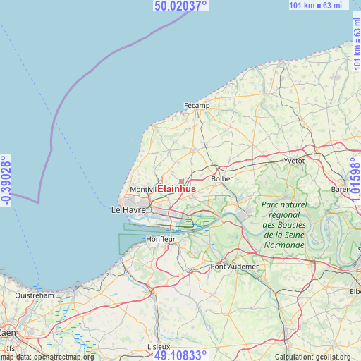
Étainhus GPS coordinates[2]
49° 33' 59.328" North, 0° 18' 46.26" East
| Map corner | latitude | longitude |
|---|---|---|
| Upper-left | 50.02037°, | -0.39028° |
| Center: | 49.56648°, | 0.31285° |
| Lower-right: | 49.10833°, | 1.01598° |
| Map W x H: | 101.4×101.4 km | = 63×63mi |
| max Lat: | 51.07786° ⇑9.8% North |
| Étainhus: | 49.56648° |
| min Lat: | ⇓90.2% South 41.3874° |
| min Long | Étainhus | max Long |
| -5.08615° | 0.31285° | 9.52242° |
| W 24.7%⇐ | ⇒75.3% E |
Elevation
Elevation of Étainhus is 114 m = 374 ft, and this is 79.7 m = 261 ft below average elevation for this country.
| Max E: |
2333 m = 7654 ft | 55.9% |
| Avg. | 193.7 m = 635 ft | |
| Étainhus | 114 m = 374 ft | |
Min E: |
-1 m = -3 ft | 44.1% |
See also: France elevation on elevation.city.
Geographical zone
Étainhus is located in North temperate zone (between Tropic of Cancer and the Arctic Circle). Distance of this North polar circle is 1889.9 km =1174.3 mi to North.| Distance of | km | miles | from Étainhus |
|---|---|---|---|
| North Pole | 4495.8 | 2793.6 | to North |
| Arctic Circle | 1889.9 | 1174.3 | to North |
| Tropic Cancer | 2905.4 | 1805.3 | to South |
| Equator | 5511.3 | 3424.6 | to South |


Nearby cities:
15 places around Étainhus: (largest is in red/bold)
• Angerville-l’Orcher
3.3 km =2.1 mi,  317°
317°
• Gainneville
6.5 km =4 mi,  214°
214°
• Gommerville
4.2 km =2.6 mi,  106°
106°
• Graimbouville
1.7 km =1.1 mi,  54°
54°
• Manneville-la-Goupil
5.7 km =3.5 mi,  31°
31°
• Manéglise
4.1 km =2.5 mi,  268°
268°
• Sainneville
2.1 km =1.3 mi,  236°
236°
• Saint-Aubin-Routot
4.9 km =3 mi,  168°
168°
• Saint-Gilles-de-la-Neuville
4.6 km =2.9 mi,  78°
78°
• Saint-Laurent-de-Brévedent
6.2 km =3.9 mi,  222°
222°
• Saint-Martin-du-Manoir
6.6 km =4.1 mi,  234°
234°
• Saint-Romain-de-Colbosc
5.1 km =3.2 mi,  141°
141°
• Turretot
7.4 km =4.6 mi,  309°
309°
• Épouville
6.4 km =4 mi, 267°
• Épretot
3.1 km =1.9 mi, 174°
Sources, notices
• [Note1] Compared only with cities in France existing in our database
• [Src1] Map data: © OpenStreetMap contributors (CC-BY-SA)
• [Src2] Other city data from geonames.org with taken over terms of usage.
• [Src3] Geographical zone / Annual Mean Temperature by Robert A. Rohde @ Wikipedia
