Fontenay geodata
Fontenay (Normandy) is a populated place; located in France in Europe/Paris (GMT+2) time zone. With population of 1,069 people, there are 8340 cities with bigger population in this country. Compared to other cities in France, 90.1% of cities are located further ↓South; 76.4% of cities are located further →East and 85.9% of cities have higher elevation than Fontenay. Note1
Administrative division(s):
- Level 1: Normandy
- Level 2: Seine-Maritime
- Level 3: Arrondissement du Havre
- Level 4: Fontenay


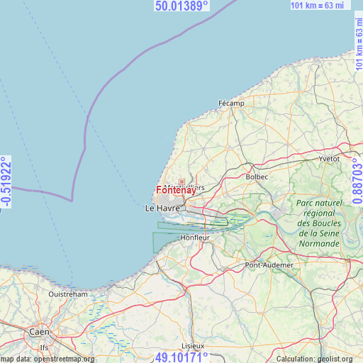
Fontenay GPS coordinates[2]
49° 33' 35.748" North, 0° 11' 2.076" East
| Map corner | latitude | longitude |
|---|---|---|
| Upper-left | 50.01389°, | -0.51922° |
| Center: | 49.55993°, | 0.18391° |
| Lower-right: | 49.10171°, | 0.88703° |
| Map W x H: | 101.4×101.4 km | = 63×63mi |
| max Lat: | 51.07786° ⇑9.9% North |
| Fontenay: | 49.55993° |
| min Lat: | ⇓90.1% South 41.3874° |
| min Long | Fontenay | max Long |
| -5.08615° | 0.18391° | 9.52242° |
| W 23.6%⇐ | ⇒76.4% E |
Elevation
Elevation of Fontenay is 40 m = 131 ft, and this is 153.7 m = 504 ft below average elevation for this country.
| Max E: |
2333 m = 7654 ft | 85.9% |
| Avg. | 193.7 m = 635 ft | |
| Fontenay | 40 m = 131 ft | |
Min E: |
-1 m = -3 ft | 14.1% |
See also: France elevation on elevation.city.
Geographical zone
Fontenay is located in North temperate zone (between Tropic of Cancer and the Arctic Circle). Distance of this North polar circle is 1890.6 km =1174.8 mi to North.| Distance of | km | miles | from Fontenay |
|---|---|---|---|
| North Pole | 4496.5 | 2794 | to North |
| Arctic Circle | 1890.6 | 1174.8 | to North |
| Tropic Cancer | 2904.6 | 1804.8 | to South |
| Equator | 5510.5 | 3424.1 | to South |


Nearby cities:
15 places around Fontenay: (largest is in red/bold)
• Cauville-sur-Mer
5.8 km =3.6 mi,  320°
320°
• Fontaine-la-Mallet
3.8 km =2.4 mi,  225°
225°
• Gainneville
7.3 km =4.5 mi,  129°
129°
• Harfleur
6 km =3.7 mi,  170°
170°
• Heuqueville
6.8 km =4.2 mi,  336°
336°
• Mannevillette
4.2 km =2.6 mi,  351°
351°
• Manéglise
5.2 km =3.2 mi,  82°
82°
• Montivilliers
1.7 km =1.1 mi, 170°
• Octeville-sur-Mer
4.9 km =3 mi,  263°
263°
• Rolleville
3.2 km =2 mi,  38°
38°
• Saint-Laurent-de-Brévedent
6.4 km =4 mi, 126°
• Saint-Martin-du-Bec
5.1 km =3.2 mi,  22°
22°
• Saint-Martin-du-Manoir
5 km =3.1 mi, 128°
• Turretot
6.6 km =4.1 mi,  33°
33°
• Épouville
2.9 km =1.8 mi, 82°
Sources, notices
• [Note1] Compared only with cities in France existing in our database
• [Src1] Map data: © OpenStreetMap contributors (CC-BY-SA)
• [Src2] Other city data from geonames.org with taken over terms of usage.
• [Src3] Geographical zone / Annual Mean Temperature by Robert A. Rohde @ Wikipedia
