Manéglise geodata
Manéglise (Normandy) is a populated place; located in France in Europe/Paris (GMT+2) time zone. With population of 1,172 people, there are 7694 cities with bigger population in this country. Compared to other cities in France, 90.2% of cities are located further ↓South; 75.7% of cities are located further →East and 73.6% of cities have higher elevation than Manéglise. Note1
Administrative division(s):
- Level 1: Normandy
- Level 2: Seine-Maritime
- Level 3: Arrondissement du Havre
- Level 4: Manéglise


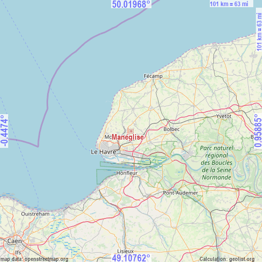
Manéglise GPS coordinates[2]
49° 33' 56.808" North, 0° 15' 20.592" East
| Map corner | latitude | longitude |
|---|---|---|
| Upper-left | 50.01968°, | -0.4474° |
| Center: | 49.56578°, | 0.25572° |
| Lower-right: | 49.10762°, | 0.95885° |
| Map W x H: | 101.4×101.4 km | = 63×63mi |
| max Lat: | 51.07786° ⇑9.8% North |
| Manéglise: | 49.56578° |
| min Lat: | ⇓90.2% South 41.3874° |
| min Long | Manéglise | max Long |
| -5.08615° | 0.25572° | 9.52242° |
| W 24.3%⇐ | ⇒75.7% E |
Elevation
Elevation of Manéglise is 70 m = 230 ft, and this is 123.7 m = 406 ft below average elevation for this country.
| Max E: |
2333 m = 7654 ft | 73.6% |
| Avg. | 193.7 m = 635 ft | |
| Manéglise | 70 m = 230 ft | |
Min E: |
-1 m = -3 ft | 26.4% |
See also: France elevation on elevation.city.
Geographical zone
Manéglise is located in North temperate zone (between Tropic of Cancer and the Arctic Circle). Distance of this North polar circle is 1890 km =1174.4 mi to North.| Distance of | km | miles | from Manéglise |
|---|---|---|---|
| North Pole | 4495.9 | 2793.6 | to North |
| Arctic Circle | 1890 | 1174.4 | to North |
| Tropic Cancer | 2905.3 | 1805.3 | to South |
| Equator | 5511.2 | 3424.5 | to South |


Nearby cities:
15 places around Manéglise: (largest is in red/bold)
• Angerville-l’Orcher
3.1 km =1.9 mi,  36°
36°
• Fontenay
5.2 km =3.2 mi,  262°
262°
• Gainneville
5.3 km =3.3 mi,  175°
175°
• Graimbouville
5.6 km =3.5 mi,  79°
79°
• Mannevillette
6.8 km =4.2 mi,  301°
301°
• Montivilliers
5.4 km =3.4 mi,  244°
244°
• Rolleville
3.7 km =2.3 mi, 300°
• Sainneville
2.6 km =1.6 mi,  114°
114°
• Saint-Laurent-de-Brévedent
4.5 km =2.8 mi, 181°
• Saint-Martin-du-Bec
5.1 km =3.2 mi,  321°
321°
• Saint-Martin-du-Manoir
4 km =2.5 mi,  199°
199°
• Turretot
5.1 km =3.2 mi,  342°
342°
• Épouville
2.3 km =1.4 mi, 263°
• Épretot
5.3 km =3.3 mi,  124°
124°
• Étainhus
4.1 km =2.5 mi,  88°
88°
Sources, notices
• [Note1] Compared only with cities in France existing in our database
• [Src1] Map data: © OpenStreetMap contributors (CC-BY-SA)
• [Src2] Other city data from geonames.org with taken over terms of usage.
• [Src3] Geographical zone / Annual Mean Temperature by Robert A. Rohde @ Wikipedia
