Rolleville geodata
Rolleville (Normandy) is a populated place; located in France in Europe/Paris (GMT+2) time zone. With population of 1,164 people, there are 7742 cities with bigger population in this country. Compared to other cities in France, 90.3% of cities are located further ↓South; 76.1% of cities are located further →East and 84.5% of cities have higher elevation than Rolleville. Note1
Administrative division(s):
- Level 1: Normandy
- Level 2: Seine-Maritime
- Level 3: Arrondissement du Havre
- Level 4: Rolleville


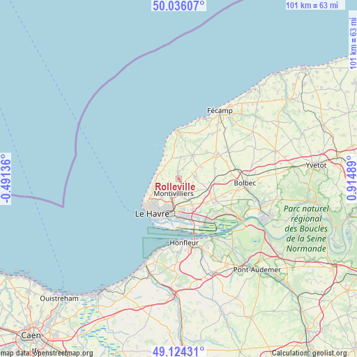
Rolleville GPS coordinates[2]
49° 34' 56.352" North, 0° 12' 42.372" East
| Map corner | latitude | longitude |
|---|---|---|
| Upper-left | 50.03607°, | -0.49136° |
| Center: | 49.58232°, | 0.21177° |
| Lower-right: | 49.12431°, | 0.91489° |
| Map W x H: | 101.4×101.4 km | = 63×63mi |
| max Lat: | 51.07786° ⇑9.7% North |
| Rolleville: | 49.58232° |
| min Lat: | ⇓90.3% South 41.3874° |
| min Long | Rolleville | max Long |
| -5.08615° | 0.21177° | 9.52242° |
| W 23.9%⇐ | ⇒76.1% E |
Elevation
Elevation of Rolleville is 43 m = 141 ft, and this is 150.7 m = 494 ft below average elevation for this country.
| Max E: |
2333 m = 7654 ft | 84.5% |
| Avg. | 193.7 m = 635 ft | |
| Rolleville | 43 m = 141 ft | |
Min E: |
-1 m = -3 ft | 15.5% |
See also: France elevation on elevation.city.
Geographical zone
Rolleville is located in North temperate zone (between Tropic of Cancer and the Arctic Circle). Distance of this North polar circle is 1888.1 km =1173.2 mi to North.| Distance of | km | miles | from Rolleville |
|---|---|---|---|
| North Pole | 4494 | 2792.4 | to North |
| Arctic Circle | 1888.1 | 1173.2 | to North |
| Tropic Cancer | 2907.1 | 1806.4 | to South |
| Equator | 5513 | 3425.6 | to South |


Nearby cities:
15 places around Rolleville: (largest is in red/bold)
• Angerville-l’Orcher
5.1 km =3.2 mi,  82°
82°
• Cauville-sur-Mer
6 km =3.7 mi,  289°
289°
• Fontaine-la-Mallet
7 km =4.3 mi,  222°
222°
• Fontenay
3.2 km =2 mi, 218°
• Gonneville-la-Mallet
6.4 km =4 mi,  6°
6°
• Heuqueville
6.1 km =3.8 mi,  308°
308°
• Mannevillette
3.1 km =1.9 mi,  302°
302°
• Manéglise
3.7 km =2.3 mi,  120°
120°
• Montivilliers
4.5 km =2.8 mi,  202°
202°
• Sainneville
6.2 km =3.9 mi, 117°
• Saint-Laurent-de-Brévedent
7 km =4.3 mi,  153°
153°
• Saint-Martin-du-Bec
2.2 km =1.4 mi,  359°
359°
• Saint-Martin-du-Manoir
5.9 km =3.7 mi,  161°
161°
• Turretot
3.4 km =2.1 mi,  28°
28°
• Épouville
2.3 km =1.4 mi, 157°
Sources, notices
• [Note1] Compared only with cities in France existing in our database
• [Src1] Map data: © OpenStreetMap contributors (CC-BY-SA)
• [Src2] Other city data from geonames.org with taken over terms of usage.
• [Src3] Geographical zone / Annual Mean Temperature by Robert A. Rohde @ Wikipedia
