Trévoux geodata
Trévoux (Auvergne-Rhône-Alpes) is a populated place; located in France in Europe/Paris (GMT+2) time zone. With population of 6,957 people, there are 1418 cities with bigger population in this country. Compared to other cities in France, 67% of cities are located further ↑North; 74.7% of cities are located further ←West and 74.4% of cities have lower elevation than Trévoux. Note1
Administrative division(s):
- Level 1: Auvergne-Rhône-Alpes
- Level 2: Département de l'Ain
- Level 3: Arrondissement de Bourg-en-Bresse
- Level 4: Trévoux


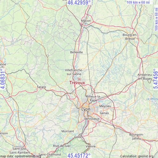
Trévoux GPS coordinates[2]
45° 56' 34.116" North, 4° 46' 17.148" East
| Map corner | latitude | longitude |
|---|---|---|
| Upper-left | 46.42959°, | 4.06831° |
| Center: | 45.94281°, | 4.77143° |
| Lower-right: | 45.45172°, | 5.47456° |
| Map W x H: | 108.7×108.7 km | = 67.5×67.5mi |
| max Lat: | 51.07786° ⇑67% North |
| Trévoux: | 45.94281° |
| min Lat: | ⇓33% South 41.3874° |
| min Long | Trévoux | max Long |
| -5.08615° | 4.77143° | 9.52242° |
| W 74.7%⇐ | ⇒25.3% E |
Elevation
Elevation of Trévoux is 245 m = 804 ft, and this is 51.3 m = 168 ft above average elevation for this country.
| Max E: |
2333 m = 7654 ft | 25.6% |
| Trévoux | 245 m 804 ft | |
| Avg. | 193.7 m = 635 ft | |
Min E: |
-1 m = -3 ft | 74.4% |
See also: France elevation on elevation.city.
Geographical zone
Trévoux is located in North temperate zone (between Tropic of Cancer and the Arctic Circle). Distance of this North polar circle is 2292.8 km =1424.7 mi to North.| Distance of | km | miles | from Trévoux |
|---|---|---|---|
| North Pole | 4898.7 | 3043.9 | to North |
| Arctic Circle | 2292.8 | 1424.7 | to North |
| Tropic Cancer | 2502.4 | 1554.9 | to South |
| Equator | 5108.4 | 3174.2 | to South |


Nearby cities:
15 places around Trévoux: (largest is in red/bold)
• Anse
4.1 km =2.5 mi,  258°
258°
• Frans
5.6 km =3.5 mi,  5°
5°
• Jassans-Riottier
4.4 km =2.7 mi,  349°
349°
• Les Chères
6.3 km =3.9 mi,  200°
200°
• Limas
6.3 km =3.9 mi,  305°
305°
• Lucenay
6.3 km =3.9 mi,  237°
237°
• Massieux
6 km =3.7 mi,  127°
127°
• Misérieux
4.8 km =3 mi,  42°
42°
• Parcieux
5 km =3.1 mi, 125°
• Pommiers
6.3 km =3.9 mi,  282°
282°
• Quincieux
3.3 km =2.1 mi,  172°
172°
• Reyrieux
3.4 km =2.1 mi,  103°
103°
• Saint-Didier-de-Formans
2.1 km =1.3 mi,  27°
27°
• Sainte-Euphémie
3.8 km =2.4 mi, 33°
• Toussieux
5 km =3.1 mi,  70°
70°
Sources, notices
• [Note1] Compared only with cities in France existing in our database
• [Src1] Map data: © OpenStreetMap contributors (CC-BY-SA)
• [Src2] Other city data from geonames.org with taken over terms of usage.
• [Src3] Geographical zone / Annual Mean Temperature by Robert A. Rohde @ Wikipedia
