Pommiers geodata
Pommiers (Auvergne-Rhône-Alpes) is a populated place; located in France in Europe/Paris (GMT+2) time zone. With population of 1,934 people, there are 4955 cities with bigger population in this country. Compared to other cities in France, 66.8% of cities are located further ↑North; 73.6% of cities are located further ←West and 82.4% of cities have lower elevation than Pommiers. Note1
Administrative division(s):
- Level 1: Auvergne-Rhône-Alpes
- Level 2: Département du Rhône
- Level 3: Arrondissement de Villefranche-sur-Saône
- Level 4: Pommiers


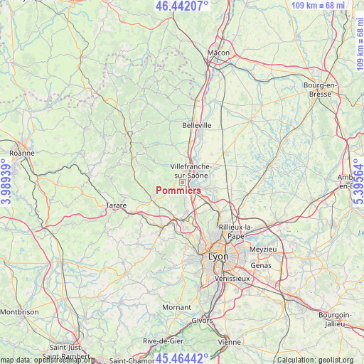
Pommiers GPS coordinates[2]
45° 57' 19.44" North, 4° 41' 33.036" East
| Map corner | latitude | longitude |
|---|---|---|
| Upper-left | 46.44207°, | 3.98939° |
| Center: | 45.9554°, | 4.69251° |
| Lower-right: | 45.46442°, | 5.39564° |
| Map W x H: | 108.7×108.7 km | = 67.5×67.5mi |
| max Lat: | 51.07786° ⇑66.8% North |
| Pommiers: | 45.9554° |
| min Lat: | ⇓33.2% South 41.3874° |
| min Long | Pommiers | max Long |
| -5.08615° | 4.69251° | 9.52242° |
| W 73.6%⇐ | ⇒26.4% E |
Elevation
Elevation of Pommiers is 315 m = 1033 ft, and this is 121.3 m = 398 ft above average elevation for this country.
| Max E: |
2333 m = 7654 ft | 17.6% |
| Pommiers | 315 m 1033 ft | |
| Avg. | 193.7 m = 635 ft | |
Min E: |
-1 m = -3 ft | 82.4% |
See also: France elevation on elevation.city.
Geographical zone
Pommiers is located in North temperate zone (between Tropic of Cancer and the Arctic Circle). Distance of this North polar circle is 2291.4 km =1423.8 mi to North.| Distance of | km | miles | from Pommiers |
|---|---|---|---|
| North Pole | 4897.3 | 3043 | to North |
| Arctic Circle | 2291.4 | 1423.8 | to North |
| Tropic Cancer | 2503.8 | 1555.8 | to South |
| Equator | 5109.8 | 3175.1 | to South |


Nearby cities:
15 places around Pommiers: (largest is in red/bold)
• Alix
5.6 km =3.5 mi,  212°
212°
• Anse
3 km =1.9 mi,  136°
136°
• Gleizé
3.8 km =2.4 mi,  5°
5°
• Jarnioux
5.1 km =3.2 mi,  281°
281°
• Jassans-Riottier
6.1 km =3.8 mi,  61°
61°
• Lacenas
5.1 km =3.2 mi,  313°
313°
• Lachassagne
3.4 km =2.1 mi,  186°
186°
• Liergues
2.9 km =1.8 mi, 307°
• Limas
2.5 km =1.6 mi,  24°
24°
• Lucenay
4.8 km =3 mi,  170°
170°
• Marcy
4.6 km =2.9 mi, 190°
• Pouilly-le-Monial
3.5 km =2.2 mi,  273°
273°
• Theizé
6.1 km =3.8 mi,  253°
253°
• Trévoux
6.3 km =3.9 mi,  102°
102°
• Villefranche-sur-Saône
4.3 km =2.7 mi,  28°
28°
Sources, notices
• [Note1] Compared only with cities in France existing in our database
• [Src1] Map data: © OpenStreetMap contributors (CC-BY-SA)
• [Src2] Other city data from geonames.org with taken over terms of usage.
• [Src3] Geographical zone / Annual Mean Temperature by Robert A. Rohde @ Wikipedia
