Frans geodata
Frans (Auvergne-Rhône-Alpes) is a populated place; located in France in Europe/Paris (GMT+2) time zone. With population of 2,023 people, there are 4733 cities with bigger population in this country. Compared to other cities in France, 66.3% of cities are located further ↑North; 74.8% of cities are located further ←West and 74.4% of cities have lower elevation than Frans. Note1
Administrative division(s):
- Level 1: Auvergne-Rhône-Alpes
- Level 2: Département de l'Ain
- Level 3: Arrondissement de Bourg-en-Bresse
- Level 4: Frans


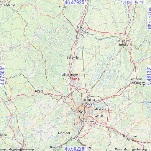
Frans GPS coordinates[2]
45° 59' 34.476" North, 4° 46' 41.52" East
| Map corner | latitude | longitude |
|---|---|---|
| Upper-left | 46.47925°, | 4.07508° |
| Center: | 45.99291°, | 4.7782° |
| Lower-right: | 45.50226°, | 5.48133° |
| Map W x H: | 108.6×108.6 km | = 67.5×67.5mi |
| max Lat: | 51.07786° ⇑66.3% North |
| Frans: | 45.99291° |
| min Lat: | ⇓33.7% South 41.3874° |
| min Long | Frans | max Long |
| -5.08615° | 4.7782° | 9.52242° |
| W 74.8%⇐ | ⇒25.2% E |
Elevation
Elevation of Frans is 245 m = 804 ft, and this is 51.3 m = 168 ft above average elevation for this country.
| Max E: |
2333 m = 7654 ft | 25.6% |
| Frans | 245 m 804 ft | |
| Avg. | 193.7 m = 635 ft | |
Min E: |
-1 m = -3 ft | 74.4% |
See also: France elevation on elevation.city.
Geographical zone
Frans is located in North temperate zone (between Tropic of Cancer and the Arctic Circle). Distance of this North polar circle is 2287.2 km =1421.2 mi to North.| Distance of | km | miles | from Frans |
|---|---|---|---|
| North Pole | 4893.1 | 3040.4 | to North |
| Arctic Circle | 2287.2 | 1421.2 | to North |
| Tropic Cancer | 2508 | 1558.4 | to South |
| Equator | 5113.9 | 3177.6 | to South |


Nearby cities:
15 places around Frans: (largest is in red/bold)
• Ars-sur-Formans
3.2 km =2 mi,  86°
86°
• Beauregard
2 km =1.2 mi,  290°
290°
• Chaleins
4.9 km =3 mi,  28°
28°
• Fareins
3.2 km =2 mi,  335°
335°
• Gleizé
6.3 km =3.9 mi,  266°
266°
• Jassans-Riottier
1.8 km =1.1 mi,  225°
225°
• Limas
5.9 km =3.7 mi,  251°
251°
• Misérieux
3.4 km =2.1 mi,  127°
127°
• Saint-Didier-de-Formans
3.7 km =2.3 mi,  173°
173°
• Sainte-Euphémie
2.9 km =1.8 mi,  147°
147°
• Savigneux
5.4 km =3.4 mi,  80°
80°
• Toussieux
5.7 km =3.5 mi, 132°
• Trévoux
5.6 km =3.5 mi,  185°
185°
• Villefranche-sur-Saône
4.5 km =2.8 mi, 265°
• Villeneuve
5.4 km =3.4 mi,  55°
55°
Sources, notices
• [Note1] Compared only with cities in France existing in our database
• [Src1] Map data: © OpenStreetMap contributors (CC-BY-SA)
• [Src2] Other city data from geonames.org with taken over terms of usage.
• [Src3] Geographical zone / Annual Mean Temperature by Robert A. Rohde @ Wikipedia
