Vidauban geodata
Vidauban (Provence-Alpes-Côte d'Azur) is a populated place; located in France in Europe/Paris (GMT+2) time zone. With population of 7,931 people, there are 1222 cities with bigger population in this country. Compared to other cities in France, 94% of cities are located further ↑North; 91.3% of cities are located further ←West and 71.9% of cities have higher elevation than Vidauban. Note1
Administrative division(s):
- Level 1: Provence-Alpes-Côte d'Azur
- Level 2: Var
- Level 3: Arrondissement de Draguignan
- Level 4: Vidauban


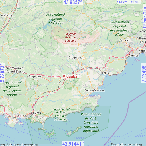
Vidauban GPS coordinates[2]
43° 25' 37.956" North, 6° 25' 54.66" East
| Map corner | latitude | longitude |
|---|---|---|
| Upper-left | 43.9357°, | 5.72873° |
| Center: | 43.42721°, | 6.43185° |
| Lower-right: | 42.91441°, | 7.13498° |
| Map W x H: | 113.6×113.6 km | = 70.6×70.6mi |
| max Lat: | 51.07786° ⇑94% North |
| Vidauban: | 43.42721° |
| min Lat: | ⇓6% South 41.3874° |
| min Long | Vidauban | max Long |
| -5.08615° | 6.43185° | 9.52242° |
| W 91.3%⇐ | ⇒8.7% E |
Elevation
Elevation of Vidauban is 74 m = 243 ft, and this is 119.7 m = 393 ft below average elevation for this country.
| Max E: |
2333 m = 7654 ft | 71.9% |
| Avg. | 193.7 m = 635 ft | |
| Vidauban | 74 m = 243 ft | |
Min E: |
-1 m = -3 ft | 28.1% |
See also: France elevation on elevation.city.
Geographical zone
Vidauban is located in North temperate zone (between Tropic of Cancer and the Arctic Circle). Distance of this Northern Tropic circle is 2222.7 km =1381.1 mi to South.| Distance of | km | miles | from Vidauban |
|---|---|---|---|
| North Pole | 5178.4 | 3217.7 | to North |
| Arctic Circle | 2572.5 | 1598.5 | to North |
| Tropic Cancer | 2222.7 | 1381.1 | to South |
| Equator | 4828.7 | 3000.4 | to South |


Nearby cities:
15 places around Vidauban: (largest is in red/bold)
• Draguignan
12.5 km =7.8 mi,  12°
12°
• Figanières
16.6 km =10.3 mi,  18°
18°
• Flayosc
12.2 km =7.6 mi,  346°
346°
• La Garde-Freinet
12.6 km =7.8 mi,  166°
166°
• La Motte
11.2 km =7 mi,  48°
48°
• Le Cannet-des-Maures
8.4 km =5.2 mi,  242°
242°
• Le Luc
10.3 km =6.4 mi,  249°
249°
• Le Muy
12 km =7.5 mi,  64°
64°
• Le Plan-de-la-Tour
14.1 km =8.8 mi,  137°
137°
• Le Thoronet
10.7 km =6.6 mi,  284°
284°
• Les Arcs
5.5 km =3.4 mi,  43°
43°
• Les Mayons
14 km =8.7 mi,  205°
205°
• Lorgues
9.3 km =5.8 mi,  322°
322°
• Taradeau
3 km =1.9 mi, 353°
• Trans-en-Provence
9.5 km =5.9 mi,  27°
27°
Sources, notices
• [Note1] Compared only with cities in France existing in our database
• [Src1] Map data: © OpenStreetMap contributors (CC-BY-SA)
• [Src2] Other city data from geonames.org with taken over terms of usage.
• [Src3] Geographical zone / Annual Mean Temperature by Robert A. Rohde @ Wikipedia
