Roquebrune-sur-Argens geodata
Roquebrune-sur-Argens (Provence-Alpes-Côte d'Azur) is a populated place; located in France in Europe/Paris (GMT+2) time zone. With population of 12,485 people, there are 762 cities with bigger population in this country. Compared to other cities in France, 93.8% of cities are located further ↑North; 92.6% of cities are located further ←West and 94.4% of cities have higher elevation than Roquebrune-sur-Argens. Note1
Administrative division(s):
- Level 1: Provence-Alpes-Côte d'Azur
- Level 2: Var
- Level 3: Arrondissement de Draguignan
- Level 4: Roquebrune-sur-Argens


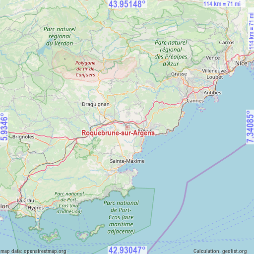
Roquebrune-sur-Argens GPS coordinates[2]
43° 26' 35.268" North, 6° 38' 15.792" East
| Map corner | latitude | longitude |
|---|---|---|
| Upper-left | 43.95148°, | 5.9346° |
| Center: | 43.44313°, | 6.63772° |
| Lower-right: | 42.93047°, | 7.34085° |
| Map W x H: | 113.5×113.5 km | = 70.5×70.5mi |
| max Lat: | 51.07786° ⇑93.8% North |
| Roquebrune-sur-Argens: | 43.44313° |
| min Lat: | ⇓6.2% South 41.3874° |
| min Long | Roquebrune-sur- | max Long |
| -5.08615° | 6.63772° | 9.52242° |
| W 92.6%⇐ | ⇒7.4% E |
Elevation
Elevation of Roquebrune-sur-Argens is 19 m = 62 ft, and this is 174.7 m = 573 ft below average elevation for this country.
| Max E: |
2333 m = 7654 ft | 94.4% |
| Avg. | 193.7 m = 635 ft | |
| Roquebrune-sur-Argens | 19 m = 62 ft | |
Min E: |
-1 m = -3 ft | 5.6% |
See also: France elevation on elevation.city.
Geographical zone
Roquebrune-sur-Argens is located in North temperate zone (between Tropic of Cancer and the Arctic Circle). Distance of this Northern Tropic circle is 2224.5 km =1382.2 mi to South.| Distance of | km | miles | from Roquebrune-sur-Argens |
|---|---|---|---|
| North Pole | 5176.6 | 3216.6 | to North |
| Arctic Circle | 2570.8 | 1597.4 | to North |
| Tropic Cancer | 2224.5 | 1382.2 | to South |
| Equator | 4830.4 | 3001.5 | to South |


Nearby cities:
15 places around Roquebrune-sur-Argens: (largest is in red/bold)
• Bagnols-en-Forêt
11.6 km =7.2 mi,  24°
24°
• Draguignan
17.4 km =10.8 mi,  306°
306°
• Figanières
18 km =11.2 mi,  320°
320°
• Fréjus
8 km =5 mi,  97°
97°
• La Motte
10 km =6.2 mi,  304°
304°
• Le Muy
6.6 km =4.1 mi, 299°
• Le Plan-de-la-Tour
14.1 km =8.8 mi,  210°
210°
• Les Arcs
13 km =8.1 mi,  279°
279°
• Puget-sur-Argens
4.1 km =2.5 mi,  69°
69°
• Saint-Paul-en-Forêt
14.5 km =9 mi, 17°
• Saint-Raphaël
11.2 km =7 mi, 101°
• Sainte-Maxime
14.9 km =9.3 mi,  179°
179°
• Taradeau
17 km =10.6 mi,  274°
274°
• Trans-en-Provence
13.9 km =8.6 mi, 298°
• Vidauban
16.7 km =10.4 mi,  263°
263°
In other languages:
- In France: Roquebrune-sur-Argens, Roquebrune-sur Argens
- In Russian: Рокбрюн-сюр-Аржанс
- In Chinese: 阿尔冈河畔罗屈埃布吕纳
Sources, notices
• [Note1] Compared only with cities in France existing in our database
• [Src1] Map data: © OpenStreetMap contributors (CC-BY-SA)
• [Src2] Other city data from geonames.org with taken over terms of usage.
• [Src3] Geographical zone / Annual Mean Temperature by Robert A. Rohde @ Wikipedia
