Lorgues geodata
Lorgues (Provence-Alpes-Côte d'Azur) is a populated place; located in France in Europe/Paris (GMT+2) time zone. With population of 8,237 people, there are 1176 cities with bigger population in this country. Compared to other cities in France, 93.1% of cities are located further ↑North; 90.8% of cities are located further ←West and 69.4% of cities have lower elevation than Lorgues. Note1
Administrative division(s):
- Level 1: Provence-Alpes-Côte d'Azur
- Level 2: Var
- Level 3: Arrondissement de Draguignan
- Level 4: Lorgues


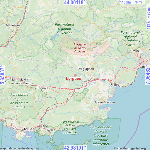
Lorgues GPS coordinates[2]
43° 29' 35.7" North, 6° 21' 41.4" East
| Map corner | latitude | longitude |
|---|---|---|
| Upper-left | 44.00118°, | 5.65837° |
| Center: | 43.49325°, | 6.3615° |
| Lower-right: | 42.98101°, | 7.06462° |
| Map W x H: | 113.4×113.4 km | = 70.5×70.5mi |
| max Lat: | 51.07786° ⇑93.1% North |
| Lorgues: | 43.49325° |
| min Lat: | ⇓6.9% South 41.3874° |
| min Long | Lorgues | max Long |
| -5.08615° | 6.3615° | 9.52242° |
| W 90.8%⇐ | ⇒9.2% E |
Elevation
Elevation of Lorgues is 216 m = 709 ft, and this is 22.3 m = 73 ft above average elevation for this country.
| Max E: |
2333 m = 7654 ft | 30.6% |
| Lorgues | 216 m 709 ft | |
| Avg. | 193.7 m = 635 ft | |
Min E: |
-1 m = -3 ft | 69.4% |
See also: France elevation on elevation.city.
Geographical zone
Lorgues is located in North temperate zone (between Tropic of Cancer and the Arctic Circle). Distance of this Northern Tropic circle is 2230.1 km =1385.7 mi to South.| Distance of | km | miles | from Lorgues |
|---|---|---|---|
| North Pole | 5171.1 | 3213.2 | to North |
| Arctic Circle | 2565.2 | 1593.9 | to North |
| Tropic Cancer | 2230.1 | 1385.7 | to South |
| Equator | 4836 | 3005 | to South |


Nearby cities:
15 places around Lorgues: (largest is in red/bold)
• Ampus
12.8 km =8 mi,  7°
7°
• Cabasse
13.7 km =8.5 mi,  237°
237°
• Draguignan
9.6 km =6 mi,  59°
59°
• Entrecasteaux
10 km =6.2 mi,  284°
284°
• Flayosc
5.3 km =3.3 mi,  32°
32°
• Le Cannet-des-Maures
11.4 km =7.1 mi,  188°
188°
• Le Luc
11.7 km =7.3 mi,  199°
199°
• Le Thoronet
6.5 km =4 mi,  225°
225°
• Les Arcs
10 km =6.2 mi,  109°
109°
• Salernes
12.9 km =8 mi,  307°
307°
• Taradeau
6.8 km =4.2 mi,  129°
129°
• Tourtour
11.7 km =7.3 mi,  335°
335°
• Trans-en-Provence
10.1 km =6.3 mi,  83°
83°
• Vidauban
9.3 km =5.8 mi,  142°
142°
• Villecroze
12.1 km =7.5 mi,  325°
325°
Sources, notices
• [Note1] Compared only with cities in France existing in our database
• [Src1] Map data: © OpenStreetMap contributors (CC-BY-SA)
• [Src2] Other city data from geonames.org with taken over terms of usage.
• [Src3] Geographical zone / Annual Mean Temperature by Robert A. Rohde @ Wikipedia
