Mazeray geodata
Mazeray (Nouvelle-Aquitaine) is a populated place; located in France in Europe/Paris (GMT+2) time zone. With population of 843 people, there are 10148 cities with bigger population in this country. Compared to other cities in France, 67.5% of cities are located further ↑North; 84.1% of cities are located further →East and 72.3% of cities have higher elevation than Mazeray. Note1
Administrative division(s):
- Level 1: Nouvelle-Aquitaine
- Level 2: Charente-Maritime
- Level 3: Arrondissement de Saint-Jean-d'Angély
- Level 4: Mazeray


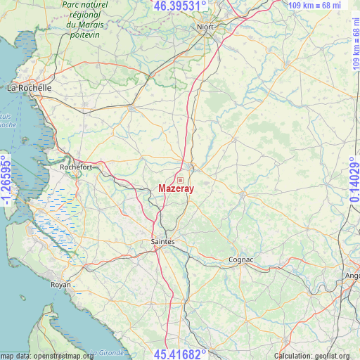
Mazeray GPS coordinates[2]
45° 54' 29.592" North, 0° 33' 46.188" West
| Map corner | latitude | longitude |
|---|---|---|
| Upper-left | 46.39531°, | -1.26595° |
| Center: | 45.90822°, | -0.56283° |
| Lower-right: | 45.41682°, | 0.14029° |
| Map W x H: | 108.8×108.8 km | = 67.6×67.6mi |
| max Lat: | 51.07786° ⇑67.5% North |
| Mazeray: | 45.90822° |
| min Lat: | ⇓32.5% South 41.3874° |
| min Long | Mazeray | max Long |
| -5.08615° | -0.56283° | 9.52242° |
| W 15.9%⇐ | ⇒84.1% E |
Elevation
Elevation of Mazeray is 73 m = 240 ft, and this is 120.7 m = 396 ft below average elevation for this country.
| Max E: |
2333 m = 7654 ft | 72.3% |
| Avg. | 193.7 m = 635 ft | |
| Mazeray | 73 m = 240 ft | |
Min E: |
-1 m = -3 ft | 27.7% |
See also: France elevation on elevation.city.
Geographical zone
Mazeray is located in North temperate zone (between Tropic of Cancer and the Arctic Circle). Distance of this North polar circle is 2296.7 km =1427.1 mi to North.| Distance of | km | miles | from Mazeray |
|---|---|---|---|
| North Pole | 4902.5 | 3046.3 | to North |
| Arctic Circle | 2296.7 | 1427.1 | to North |
| Tropic Cancer | 2498.6 | 1552.6 | to South |
| Equator | 5104.5 | 3171.8 | to South |


Nearby cities:
15 places around Mazeray: (largest is in red/bold)
• Archingeay
11.3 km =7 mi,  283°
283°
• Asnières-la-Giraud
3.8 km =2.4 mi,  122°
122°
• Aumagne
12.9 km =8 mi,  106°
106°
• Brizambourg
11.4 km =7.1 mi,  146°
146°
• La Vergne
6.3 km =3.9 mi,  358°
358°
• Landes
9.8 km =6.1 mi,  344°
344°
• Le Douhet
9.6 km =6 mi,  181°
181°
• Les Nouillers
8.2 km =5.1 mi,  288°
288°
• Saint-Hilaire-de-Villefranche
6.9 km =4.3 mi,  158°
158°
• Saint-Jean-d’Angély
5.1 km =3.2 mi,  38°
38°
• Saint-Savinien
9.6 km =6 mi,  248°
248°
• Taillebourg
10.4 km =6.5 mi,  217°
217°
• Varaize
10.8 km =6.7 mi,  81°
81°
• Vénérand
12.8 km =8 mi, 177°
• Écoyeux
10.5 km =6.5 mi, 155°
Sources, notices
• [Note1] Compared only with cities in France existing in our database
• [Src1] Map data: © OpenStreetMap contributors (CC-BY-SA)
• [Src2] Other city data from geonames.org with taken over terms of usage.
• [Src3] Geographical zone / Annual Mean Temperature by Robert A. Rohde @ Wikipedia
