Landes geodata
Landes (Nouvelle-Aquitaine) is a populated place; located in France in Europe/Paris (GMT+2) time zone. With population of 560 people, there are 14001 cities with bigger population in this country. Compared to other cities in France, 66.3% of cities are located further ↑North; 84.5% of cities are located further →East and 91.2% of cities have higher elevation than Landes. Note1
Administrative division(s):
- Level 1: Nouvelle-Aquitaine
- Level 2: Charente-Maritime
- Level 3: Arrondissement de Saint-Jean-d'Angély
- Level 4: Landes


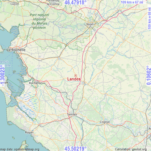
Landes GPS coordinates[2]
45° 59' 34.224" North, 0° 35' 49.596" West
| Map corner | latitude | longitude |
|---|---|---|
| Upper-left | 46.47918°, | -1.30023° |
| Center: | 45.99284°, | -0.59711° |
| Lower-right: | 45.50219°, | 0.10602° |
| Map W x H: | 108.6×108.6 km | = 67.5×67.5mi |
| max Lat: | 51.07786° ⇑66.3% North |
| Landes: | 45.99284° |
| min Lat: | ⇓33.7% South 41.3874° |
| min Long | Landes | max Long |
| -5.08615° | -0.59711° | 9.52242° |
| W 15.5%⇐ | ⇒84.5% E |
Elevation
Elevation of Landes is 27 m = 89 ft, and this is 166.7 m = 547 ft below average elevation for this country.
| Max E: |
2333 m = 7654 ft | 91.2% |
| Avg. | 193.7 m = 635 ft | |
| Landes | 27 m = 89 ft | |
Min E: |
-1 m = -3 ft | 8.8% |
See also: France elevation on elevation.city.
Geographical zone
Landes is located in North temperate zone (between Tropic of Cancer and the Arctic Circle). Distance of this North polar circle is 2287.2 km =1421.2 mi to North.| Distance of | km | miles | from Landes |
|---|---|---|---|
| North Pole | 4893.1 | 3040.4 | to North |
| Arctic Circle | 2287.2 | 1421.2 | to North |
| Tropic Cancer | 2508 | 1558.4 | to South |
| Equator | 5113.9 | 3177.6 | to South |


Nearby cities:
15 places around Landes: (largest is in red/bold)
• Archingeay
10.8 km =6.7 mi,  231°
231°
• Asnières-la-Giraud
12.9 km =8 mi,  152°
152°
• Bernay-Saint-Martin
8.3 km =5.2 mi,  349°
349°
• Genouillé
14.8 km =9.2 mi,  282°
282°
• La Vergne
4 km =2.5 mi,  140°
140°
• Les Nouillers
8.5 km =5.3 mi,  217°
217°
• Loulay
9 km =5.6 mi,  48°
48°
• Marsais
14.8 km =9.2 mi,  359°
359°
• Mazeray
9.8 km =6.1 mi,  164°
164°
• Saint-Jean-d’Angély
8 km =5 mi,  132°
132°
• Saint-Mard
13.6 km =8.5 mi,  319°
319°
• Saint-Savinien
14.3 km =8.9 mi,  206°
206°
• Tonnay-Boutonne
9 km =5.6 mi,  252°
252°
• Vandré
14.7 km =9.1 mi,  298°
298°
• Villeneuve-la-Comtesse
13.7 km =8.5 mi,  31°
31°
Sources, notices
• [Note1] Compared only with cities in France existing in our database
• [Src1] Map data: © OpenStreetMap contributors (CC-BY-SA)
• [Src2] Other city data from geonames.org with taken over terms of usage.
• [Src3] Geographical zone / Annual Mean Temperature by Robert A. Rohde @ Wikipedia
