Tinqueux geodata
Tinqueux (Grand Est) is a populated place; located in France in Europe/Paris (GMT+2) time zone. With population of 10,197 people, there are 931 cities with bigger population in this country. Compared to other cities in France, 85.2% of cities are located further ↓South; 67.7% of cities are located further ←West and 64.9% of cities have higher elevation than Tinqueux. Note1
Administrative division(s):
- Level 1: Grand Est
- Level 2: Marne
- Level 3: Arrondissement de Reims
- Level 4: Tinqueux


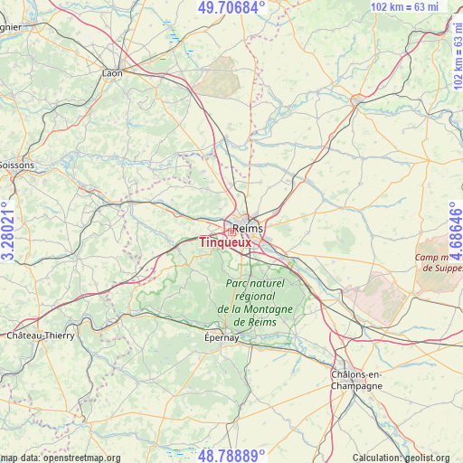
Tinqueux GPS coordinates[2]
49° 15' 0" North, 3° 58' 59.988" East
| Map corner | latitude | longitude |
|---|---|---|
| Upper-left | 49.70684°, | 3.28021° |
| Center: | 49.25°, | 3.98333° |
| Lower-right: | 48.78889°, | 4.68646° |
| Map W x H: | 102.1×102.1 km | = 63.4×63.4mi |
| max Lat: | 51.07786° ⇑14.8% North |
| Tinqueux: | 49.25° |
| min Lat: | ⇓85.2% South 41.3874° |
| min Long | Tinqueux | max Long |
| -5.08615° | 3.98333° | 9.52242° |
| W 67.7%⇐ | ⇒32.3% E |
Elevation
Elevation of Tinqueux is 90 m = 295 ft, and this is 103.7 m = 340 ft below average elevation for this country.
| Max E: |
2333 m = 7654 ft | 64.9% |
| Avg. | 193.7 m = 635 ft | |
| Tinqueux | 90 m = 295 ft | |
Min E: |
-1 m = -3 ft | 35.1% |
See also: France elevation on elevation.city.
Geographical zone
Tinqueux is located in North temperate zone (between Tropic of Cancer and the Arctic Circle). Distance of this North polar circle is 1925.1 km =1196.2 mi to North.| Distance of | km | miles | from Tinqueux |
|---|---|---|---|
| North Pole | 4531 | 2815.4 | to North |
| Arctic Circle | 1925.1 | 1196.2 | to North |
| Tropic Cancer | 2870.2 | 1783.5 | to South |
| Equator | 5476.1 | 3402.7 | to South |


Nearby cities:
15 places around Tinqueux: (largest is in red/bold)
• Bezannes
3 km =1.9 mi,  172°
172°
• Bétheny
6.5 km =4 mi,  53°
53°
• Cernay-lès-Reims
8.8 km =5.5 mi,  79°
79°
• Champigny
2.2 km =1.4 mi,  335°
335°
• Cormontreuil
6.1 km =3.8 mi,  127°
127°
• Courcy
8.3 km =5.2 mi,  9°
9°
• Gueux
5.3 km =3.3 mi,  270°
270°
• Les Mesneux
3.8 km =2.4 mi,  204°
204°
• Merfy
5.7 km =3.5 mi,  334°
334°
• Muizon
7.3 km =4.5 mi,  292°
292°
• Reims
3.7 km =2.3 mi,  62°
62°
• Saint-Brice-Courcelles
1.9 km =1.2 mi,  0°
0°
• Saint-Thierry
6.3 km =3.9 mi,  348°
348°
• Taissy
8.9 km =5.5 mi,  115°
115°
• Trigny
8.6 km =5.3 mi,  312°
312°
Sources, notices
• [Note1] Compared only with cities in France existing in our database
• [Src1] Map data: © OpenStreetMap contributors (CC-BY-SA)
• [Src2] Other city data from geonames.org with taken over terms of usage.
• [Src3] Geographical zone / Annual Mean Temperature by Robert A. Rohde @ Wikipedia
