Champigny geodata
Champigny (Grand Est) is a populated place; located in France in Europe/Paris (GMT+2) time zone. With population of 957 people, there are 9150 cities with bigger population in this country. Compared to other cities in France, 85.5% of cities are located further ↓South; 67.5% of cities are located further ←West and 69.7% of cities have higher elevation than Champigny. Note1
Administrative division(s):
- Level 1: Grand Est
- Level 2: Marne
- Level 3: Arrondissement de Reims
- Level 4: Champigny


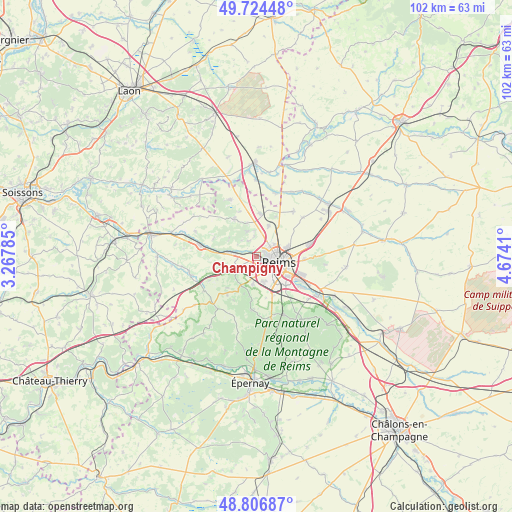
Champigny GPS coordinates[2]
49° 16' 4.116" North, 3° 58' 15.528" East
| Map corner | latitude | longitude |
|---|---|---|
| Upper-left | 49.72448°, | 3.26785° |
| Center: | 49.26781°, | 3.97098° |
| Lower-right: | 48.80687°, | 4.6741° |
| Map W x H: | 102×102 km | = 63.4×63.4mi |
| max Lat: | 51.07786° ⇑14.5% North |
| Champigny: | 49.26781° |
| min Lat: | ⇓85.5% South 41.3874° |
| min Long | Champigny | max Long |
| -5.08615° | 3.97098° | 9.52242° |
| W 67.5%⇐ | ⇒32.5% E |
Elevation
Elevation of Champigny is 79 m = 259 ft, and this is 114.7 m = 376 ft below average elevation for this country.
| Max E: |
2333 m = 7654 ft | 69.7% |
| Avg. | 193.7 m = 635 ft | |
| Champigny | 79 m = 259 ft | |
Min E: |
-1 m = -3 ft | 30.3% |
See also: France elevation on elevation.city.
Geographical zone
Champigny is located in North temperate zone (between Tropic of Cancer and the Arctic Circle). Distance of this North polar circle is 1923.1 km =1195 mi to North.| Distance of | km | miles | from Champigny |
|---|---|---|---|
| North Pole | 4529 | 2814.2 | to North |
| Arctic Circle | 1923.1 | 1195 | to North |
| Tropic Cancer | 2872.1 | 1784.6 | to South |
| Equator | 5478.1 | 3403.9 | to South |


Nearby cities:
15 places around Champigny: (largest is in red/bold)
• Bezannes
5.1 km =3.2 mi,  165°
165°
• Bétheny
6.4 km =4 mi,  72°
72°
• Cormontreuil
8.1 km =5 mi,  134°
134°
• Courcy
6.6 km =4.1 mi,  20°
20°
• Gueux
4.8 km =3 mi,  246°
246°
• Hermonville
8.8 km =5.5 mi,  329°
329°
• Les Mesneux
5.4 km =3.4 mi,  187°
187°
• Loivre
8.7 km =5.4 mi,  4°
4°
• Merfy
3.5 km =2.2 mi, 334°
• Muizon
5.9 km =3.7 mi,  277°
277°
• Reims
4.2 km =2.6 mi,  93°
93°
• Saint-Brice-Courcelles
0.9 km =0.6 mi,  98°
98°
• Saint-Thierry
4.2 km =2.6 mi,  354°
354°
• Tinqueux
2.2 km =1.4 mi,  155°
155°
• Trigny
6.7 km =4.2 mi,  305°
305°
Sources, notices
• [Note1] Compared only with cities in France existing in our database
• [Src1] Map data: © OpenStreetMap contributors (CC-BY-SA)
• [Src2] Other city data from geonames.org with taken over terms of usage.
• [Src3] Geographical zone / Annual Mean Temperature by Robert A. Rohde @ Wikipedia
