Tillé geodata
Tillé (Hauts-de-France) is a populated place; located in France in Europe/Paris (GMT+2) time zone. With population of 1,041 people, there are 8531 cities with bigger population in this country. Compared to other cities in France, 88.7% of cities are located further ↓South; 55.7% of cities are located further →East and 56.5% of cities have higher elevation than Tillé. Note1
Administrative division(s):
- Level 1: Hauts-de-France
- Level 2: Département de l'Oise
- Level 3: Arrondissement de Beauvais
- Level 4: Tillé


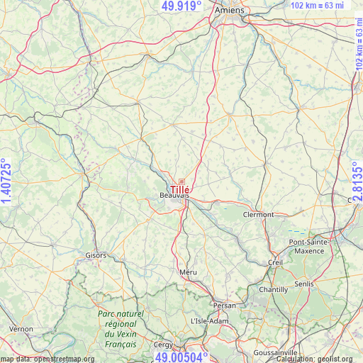
Tillé GPS coordinates[2]
49° 27' 50.94" North, 2° 6' 37.368" East
| Map corner | latitude | longitude |
|---|---|---|
| Upper-left | 49.919°, | 1.40725° |
| Center: | 49.46415°, | 2.11038° |
| Lower-right: | 49.00504°, | 2.8135° |
| Map W x H: | 101.6×101.6 km | = 63.1×63.1mi |
| max Lat: | 51.07786° ⇑11.3% North |
| Tillé: | 49.46415° |
| min Lat: | ⇓88.7% South 41.3874° |
| min Long | Tillé | max Long |
| -5.08615° | 2.11038° | 9.52242° |
| W 44.3%⇐ | ⇒55.7% E |
Elevation
Elevation of Tillé is 112 m = 367 ft, and this is 81.7 m = 268 ft below average elevation for this country.
| Max E: |
2333 m = 7654 ft | 56.5% |
| Avg. | 193.7 m = 635 ft | |
| Tillé | 112 m = 367 ft | |
Min E: |
-1 m = -3 ft | 43.5% |
See also: France elevation on elevation.city.
Geographical zone
Tillé is located in North temperate zone (between Tropic of Cancer and the Arctic Circle). Distance of this North polar circle is 1901.3 km =1181.4 mi to North.| Distance of | km | miles | from Tillé |
|---|---|---|---|
| North Pole | 4507.2 | 2800.6 | to North |
| Arctic Circle | 1901.3 | 1181.4 | to North |
| Tropic Cancer | 2894 | 1798.2 | to South |
| Equator | 5499.9 | 3417.5 | to South |


Nearby cities:
15 places around Tillé: (largest is in red/bold)
• Abbeville-Saint-Lucien
7.2 km =4.5 mi,  36°
36°
• Allonne
6.2 km =3.9 mi,  177°
177°
• Aux Marais
7.4 km =4.6 mi,  222°
222°
• Beauvais
3.9 km =2.4 mi,  209°
209°
• Goincourt
6.8 km =4.2 mi,  231°
231°
• Herchies
7.7 km =4.8 mi,  290°
290°
• Laversines
7.7 km =4.8 mi,  124°
124°
• Le Mont-Saint-Adrien
7.9 km =4.9 mi,  255°
255°
• Oroër
5.2 km =3.2 mi,  46°
46°
• Saint-Martin-le-Nœud
8.3 km =5.2 mi, 205°
• Saint-Paul
8.4 km =5.2 mi,  242°
242°
• Therdonne
6.2 km =3.9 mi,  145°
145°
• Troissereux
5.1 km =3.2 mi, 290°
• Verderel-lès-Sauqueuse
4.1 km =2.5 mi,  349°
349°
• Warluis
8.7 km =5.4 mi,  164°
164°
Sources, notices
• [Note1] Compared only with cities in France existing in our database
• [Src1] Map data: © OpenStreetMap contributors (CC-BY-SA)
• [Src2] Other city data from geonames.org with taken over terms of usage.
• [Src3] Geographical zone / Annual Mean Temperature by Robert A. Rohde @ Wikipedia
