Abbeville-Saint-Lucien geodata
Abbeville-Saint-Lucien (Hauts-de-France) is a populated place; located in France in Europe/Paris (GMT+2) time zone. With population of 567 people, there are 13878 cities with bigger population in this country. Compared to other cities in France, 89.5% of cities are located further ↓South; 54.9% of cities are located further →East and 55% of cities have lower elevation than Abbeville-Saint-Lucien. Note1
Administrative division(s):
- Level 1: Hauts-de-France
- Level 2: Département de l'Oise
- Level 3: Arrondissement de Clermont
- Level 4: Abbeville-Saint-Lucien
Current local time in Abbeville-Saint-Lucien:
06:08 AM, SaturdayDifference from your time zone: hours


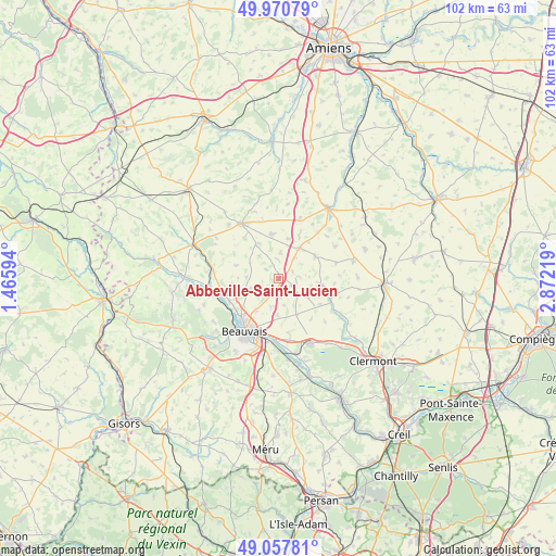
Abbeville-Saint-Lucien GPS coordinates[2]
49° 30' 59.148" North, 2° 10' 8.616" East
| Map corner | latitude | longitude |
|---|---|---|
| Upper-left | 49.97079°, | 1.46594° |
| Center: | 49.51643°, | 2.16906° |
| Lower-right: | 49.05781°, | 2.87219° |
| Map W x H: | 101.5×101.5 km | = 63.1×63.1mi |
| max Lat: | 51.07786° ⇑10.5% North |
| Abbeville-Saint-Lucien: | 49.51643° |
| min Lat: | ⇓89.5% South 41.3874° |
| min Long | Abbeville-Saint | max Long |
| -5.08615° | 2.16906° | 9.52242° |
| W 45.1%⇐ | ⇒54.9% E |
Elevation
Elevation of Abbeville-Saint-Lucien is 150 m = 492 ft, and this is 43.7 m = 143 ft below average elevation for this country.
| Max E: |
2333 m = 7654 ft | 45% |
| Avg. | 193.7 m = 635 ft | |
| Abbeville-Saint-Lucien | 150 m = 492 ft | |
Min E: |
-1 m = -3 ft | 55% |
See also: France elevation on elevation.city.
Geographical zone
Abbeville-Saint-Lucien is located in North temperate zone (between Tropic of Cancer and the Arctic Circle). Distance of this North polar circle is 1895.5 km =1177.8 mi to North.| Distance of | km | miles | from Abbeville-Saint-Lucien |
|---|---|---|---|
| North Pole | 4501.4 | 2797 | to North |
| Arctic Circle | 1895.5 | 1177.8 | to North |
| Tropic Cancer | 2899.8 | 1801.9 | to South |
| Equator | 5505.7 | 3421.1 | to South |


Nearby cities:
15 places around Abbeville-Saint-Lucien: (largest is in red/bold)
• Beauvais
11.1 km =6.9 mi,  213°
213°
• Crèvecœur-le-Grand
11.2 km =7 mi,  326°
326°
• Froissy
6.9 km =4.3 mi,  33°
33°
• Hardivillers
11.8 km =7.3 mi,  19°
19°
• Haudivillers
6.3 km =3.9 mi,  120°
120°
• Herchies
11.9 km =7.4 mi,  254°
254°
• Laversines
10.4 km =6.5 mi,  168°
168°
• Luchy
5.6 km =3.5 mi,  319°
319°
• Noyers-Saint-Martin
7.8 km =4.8 mi,  58°
58°
• Oroër
2.3 km =1.4 mi,  191°
191°
• Saint-André-Farivillers
11.8 km =7.3 mi,  48°
48°
• Therdonne
10.9 km =6.8 mi,  184°
184°
• Tillé
7.2 km =4.5 mi,  216°
216°
• Troissereux
9.8 km =6.1 mi, 245°
• Verderel-lès-Sauqueuse
5.3 km =3.3 mi, 249°
Sources, notices
• [Note1] Compared only with cities in France existing in our database
• [Src1] Map data: © OpenStreetMap contributors (CC-BY-SA)
• [Src2] Other city data from geonames.org with taken over terms of usage.
• [Src3] Geographical zone / Annual Mean Temperature by Robert A. Rohde @ Wikipedia
