Tiercé geodata
Tiercé (Pays de la Loire) is a populated place; located in France in Europe/Paris (GMT+2) time zone. With population of 3,936 people, there are 2502 cities with bigger population in this country. Compared to other cities in France, 52.9% of cities are located further ↓South; 82.9% of cities are located further →East and 91.2% of cities have higher elevation than Tiercé. Note1
Administrative division(s):
- Level 1: Pays de la Loire
- Level 2: Département de Maine-et-Loire
- Level 3: Angers
- Level 4: Tiercé


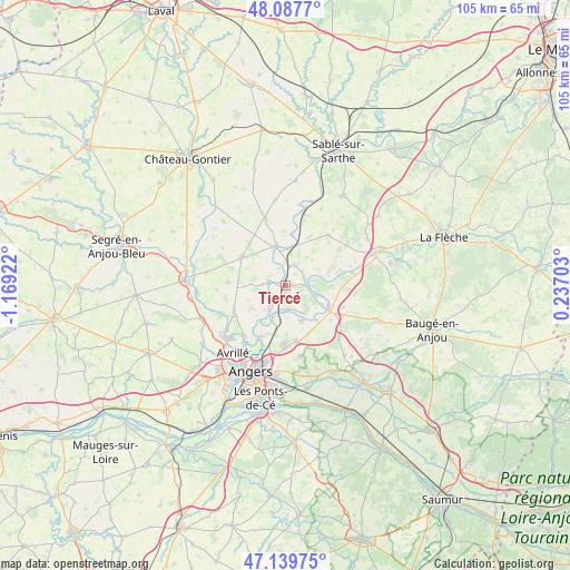
Tiercé GPS coordinates[2]
47° 36' 57.132" North, 0° 27' 57.924" West
| Map corner | latitude | longitude |
|---|---|---|
| Upper-left | 48.0877°, | -1.16922° |
| Center: | 47.61587°, | -0.46609° |
| Lower-right: | 47.13975°, | 0.23703° |
| Map W x H: | 105.4×105.4 km | = 65.5×65.5mi |
| max Lat: | 51.07786° ⇑47.1% North |
| Tiercé: | 47.61587° |
| min Lat: | ⇓52.9% South 41.3874° |
| min Long | Tiercé | max Long |
| -5.08615° | -0.46609° | 9.52242° |
| W 17.1%⇐ | ⇒82.9% E |
Elevation
Elevation of Tiercé is 27 m = 89 ft, and this is 166.7 m = 547 ft below average elevation for this country.
| Max E: |
2333 m = 7654 ft | 91.2% |
| Avg. | 193.7 m = 635 ft | |
| Tiercé | 27 m = 89 ft | |
Min E: |
-1 m = -3 ft | 8.8% |
See also: France elevation on elevation.city.
Geographical zone
Tiercé is located in North temperate zone (between Tropic of Cancer and the Arctic Circle). Distance of this North polar circle is 2106.8 km =1309.1 mi to North.| Distance of | km | miles | from Tiercé |
|---|---|---|---|
| North Pole | 4712.7 | 2928.3 | to North |
| Arctic Circle | 2106.8 | 1309.1 | to North |
| Tropic Cancer | 2688.5 | 1670.6 | to South |
| Equator | 5294.4 | 3289.8 | to South |


Nearby cities:
15 places around Tiercé: (largest is in red/bold)
• Briollay
6.4 km =4 mi,  208°
208°
• Brissarthe
9.5 km =5.9 mi,  7°
7°
• Champigné
9.5 km =5.9 mi,  303°
303°
• Cheffes
2.5 km =1.6 mi,  272°
272°
• Châteauneuf-sur-Sarthe
7.5 km =4.7 mi,  348°
348°
• Corzé
8.4 km =5.2 mi,  137°
137°
• Feneu
10.8 km =6.7 mi,  243°
243°
• Juvardeil
4.9 km =3 mi,  330°
330°
• Pellouailles-les-Vignes
10.7 km =6.6 mi,  169°
169°
• Seiches-sur-le-Loir
9.5 km =5.9 mi,  119°
119°
• Soucelles
6.4 km =4 mi,  145°
145°
• Soulaire-et-Bourg
7.7 km =4.8 mi, 237°
• Villevêque
6.9 km =4.3 mi, 152°
• Écouflant
10.5 km =6.5 mi, 206°
• Étriché
4.2 km =2.6 mi,  23°
23°
Sources, notices
• [Note1] Compared only with cities in France existing in our database
• [Src1] Map data: © OpenStreetMap contributors (CC-BY-SA)
• [Src2] Other city data from geonames.org with taken over terms of usage.
• [Src3] Geographical zone / Annual Mean Temperature by Robert A. Rohde @ Wikipedia
