Feneu geodata
Feneu (Pays de la Loire) is a populated place; located in France in Europe/Paris (GMT+2) time zone. With population of 1,899 people, there are 5035 cities with bigger population in this country. Compared to other cities in France, 52.3% of cities are located further ↓South; 84.4% of cities are located further →East and 82.2% of cities have higher elevation than Feneu. Note1
Administrative division(s):
- Level 1: Pays de la Loire
- Level 2: Département de Maine-et-Loire
- Level 3: Angers
- Level 4: Feneu


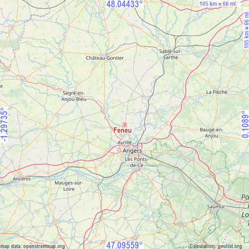
Feneu GPS coordinates[2]
47° 34' 19.596" North, 0° 35' 39.192" West
| Map corner | latitude | longitude |
|---|---|---|
| Upper-left | 48.04433°, | -1.29735° |
| Center: | 47.57211°, | -0.59422° |
| Lower-right: | 47.09559°, | 0.1089° |
| Map W x H: | 105.5×105.5 km | = 65.6×65.6mi |
| max Lat: | 51.07786° ⇑47.7% North |
| Feneu: | 47.57211° |
| min Lat: | ⇓52.3% South 41.3874° |
| min Long | Feneu | max Long |
| -5.08615° | -0.59422° | 9.52242° |
| W 15.6%⇐ | ⇒84.4% E |
Elevation
Elevation of Feneu is 49 m = 161 ft, and this is 144.7 m = 475 ft below average elevation for this country.
| Max E: |
2333 m = 7654 ft | 82.2% |
| Avg. | 193.7 m = 635 ft | |
| Feneu | 49 m = 161 ft | |
Min E: |
-1 m = -3 ft | 17.8% |
See also: France elevation on elevation.city.
Geographical zone
Feneu is located in North temperate zone (between Tropic of Cancer and the Arctic Circle). Distance of this North polar circle is 2111.7 km =1312.1 mi to North.| Distance of | km | miles | from Feneu |
|---|---|---|---|
| North Pole | 4717.5 | 2931.3 | to North |
| Arctic Circle | 2111.7 | 1312.1 | to North |
| Tropic Cancer | 2683.6 | 1667.5 | to South |
| Equator | 5289.5 | 3286.7 | to South |


Nearby cities:
15 places around Feneu: (largest is in red/bold)
• Angers
11.5 km =7.1 mi,  162°
162°
• Avrillé
8.1 km =5 mi,  174°
174°
• Beaucouzé
11.2 km =7 mi,  193°
193°
• Briollay
6.6 km =4.1 mi,  97°
97°
• Cantenay-Épinard
4.5 km =2.8 mi, 155°
• Champigné
10.3 km =6.4 mi,  9°
9°
• Cheffes
8.6 km =5.3 mi,  54°
54°
• Grez-Neuville
7.4 km =4.6 mi,  297°
297°
• La Meignanne
8.3 km =5.2 mi,  222°
222°
• La Membrolle-sur-Longuenée
6 km =3.7 mi,  256°
256°
• Le Plessis-Macé
6.8 km =4.2 mi,  241°
241°
• Pruillé
5.1 km =3.2 mi,  276°
276°
• Soulaire-et-Bourg
3.2 km =2 mi,  76°
76°
• Tiercé
10.8 km =6.7 mi,  63°
63°
• Écouflant
6.8 km =4.2 mi,  132°
132°
Sources, notices
• [Note1] Compared only with cities in France existing in our database
• [Src1] Map data: © OpenStreetMap contributors (CC-BY-SA)
• [Src2] Other city data from geonames.org with taken over terms of usage.
• [Src3] Geographical zone / Annual Mean Temperature by Robert A. Rohde @ Wikipedia
