Thorigny-sur-Marne geodata
Thorigny-sur-Marne (Île-de-France) is a populated place; located in France in Europe/Paris (GMT+2) time zone. With population of 9,887 people, there are 962 cities with bigger population in this country. Compared to other cities in France, 77.3% of cities are located further ↓South; 53.8% of cities are located further ←West and 72.6% of cities have higher elevation than Thorigny-sur-Marne. Note1
Administrative division(s):
- Level 1: Île-de-France
- Level 2: Seine-et-Marne
- Level 3: Arrondissement de Torcy
- Level 4: Thorigny-sur-Marne


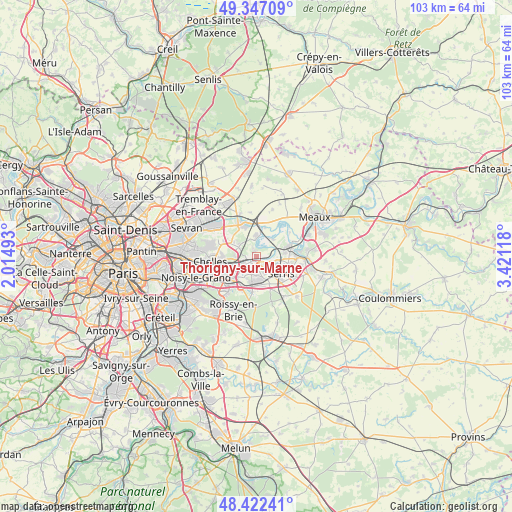
Thorigny-sur-Marne GPS coordinates[2]
48° 53' 12.804" North, 2° 43' 5.016" East
| Map corner | latitude | longitude |
|---|---|---|
| Upper-left | 49.34709°, | 2.01493° |
| Center: | 48.88689°, | 2.71806° |
| Lower-right: | 48.42241°, | 3.42118° |
| Map W x H: | 102.8×102.8 km | = 63.9×63.9mi |
| max Lat: | 51.07786° ⇑22.7% North |
| Thorigny-sur-Marne: | 48.88689° |
| min Lat: | ⇓77.3% South 41.3874° |
| min Long | Thorigny-sur-Ma | max Long |
| -5.08615° | 2.71806° | 9.52242° |
| W 53.8%⇐ | ⇒46.2% E |
Elevation
Elevation of Thorigny-sur-Marne is 72 m = 236 ft, and this is 121.7 m = 399 ft below average elevation for this country.
| Max E: |
2333 m = 7654 ft | 72.6% |
| Avg. | 193.7 m = 635 ft | |
| Thorigny-sur-Marne | 72 m = 236 ft | |
Min E: |
-1 m = -3 ft | 27.4% |
See also: France elevation on elevation.city.
Geographical zone
Thorigny-sur-Marne is located in North temperate zone (between Tropic of Cancer and the Arctic Circle). Distance of this North polar circle is 1965.5 km =1221.3 mi to North.| Distance of | km | miles | from Thorigny-sur-Marne |
|---|---|---|---|
| North Pole | 4571.3 | 2840.5 | to North |
| Arctic Circle | 1965.5 | 1221.3 | to North |
| Tropic Cancer | 2829.8 | 1758.4 | to South |
| Equator | 5435.7 | 3377.6 | to South |


Nearby cities:
15 places around Thorigny-sur-Marne: (largest is in red/bold)
• Annet-sur-Marne
4.4 km =2.7 mi,  1°
1°
• Bussy-Saint-Georges
5.2 km =3.2 mi,  193°
193°
• Bussy-Saint-Martin
4.7 km =2.9 mi,  205°
205°
• Chalifert
4.1 km =2.5 mi,  85°
85°
• Chanteloup-en-Brie
3.9 km =2.4 mi,  156°
156°
• Chessy
3.6 km =2.2 mi,  96°
96°
• Conches-sur-Gondoire
3.4 km =2.1 mi,  180°
180°
• Dampmart
1.7 km =1.1 mi,  83°
83°
• Gouvernes
3.6 km =2.2 mi, 213°
• Guermantes
3.9 km =2.4 mi, 194°
• Jablines
4.8 km =3 mi,  44°
44°
• Lagny-sur-Marne
2.3 km =1.4 mi, 182°
• Montévrain
2.8 km =1.7 mi,  120°
120°
• Pomponne
2.7 km =1.7 mi,  256°
256°
• Saint-Thibault-des-Vignes
3.3 km =2.1 mi,  237°
237°
Sources, notices
• [Note1] Compared only with cities in France existing in our database
• [Src1] Map data: © OpenStreetMap contributors (CC-BY-SA)
• [Src2] Other city data from geonames.org with taken over terms of usage.
• [Src3] Geographical zone / Annual Mean Temperature by Robert A. Rohde @ Wikipedia
