Pomponne geodata
Pomponne (Île-de-France) is a populated place; located in France in Europe/Paris (GMT+2) time zone. With population of 3,324 people, there are 2937 cities with bigger population in this country. Compared to other cities in France, 77.2% of cities are located further ↓South; 53.2% of cities are located further ←West and 81.8% of cities have higher elevation than Pomponne. Note1
Administrative division(s):
- Level 1: Île-de-France
- Level 2: Seine-et-Marne
- Level 3: Arrondissement de Torcy
- Level 4: Pomponne


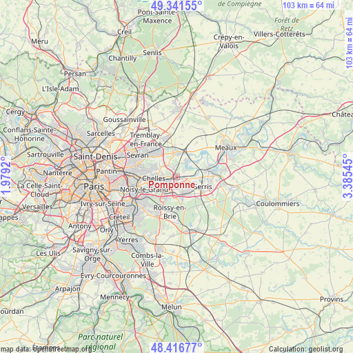
Pomponne GPS coordinates[2]
48° 52' 52.68" North, 2° 40' 56.352" East
| Map corner | latitude | longitude |
|---|---|---|
| Upper-left | 49.34155°, | 1.9792° |
| Center: | 48.8813°, | 2.68232° |
| Lower-right: | 48.41677°, | 3.38545° |
| Map W x H: | 102.8×102.8 km | = 63.9×63.9mi |
| max Lat: | 51.07786° ⇑22.8% North |
| Pomponne: | 48.8813° |
| min Lat: | ⇓77.2% South 41.3874° |
| min Long | Pomponne | max Long |
| -5.08615° | 2.68232° | 9.52242° |
| W 53.2%⇐ | ⇒46.8% E |
Elevation
Elevation of Pomponne is 50 m = 164 ft, and this is 143.7 m = 471 ft below average elevation for this country.
| Max E: |
2333 m = 7654 ft | 81.8% |
| Avg. | 193.7 m = 635 ft | |
| Pomponne | 50 m = 164 ft | |
Min E: |
-1 m = -3 ft | 18.2% |
See also: France elevation on elevation.city.
Geographical zone
Pomponne is located in North temperate zone (between Tropic of Cancer and the Arctic Circle). Distance of this North polar circle is 1966.1 km =1221.7 mi to North.| Distance of | km | miles | from Pomponne |
|---|---|---|---|
| North Pole | 4572 | 2840.9 | to North |
| Arctic Circle | 1966.1 | 1221.7 | to North |
| Tropic Cancer | 2829.2 | 1758 | to South |
| Equator | 5435.1 | 3377.2 | to South |


Nearby cities:
15 places around Pomponne: (largest is in red/bold)
• Brou-sur-Chantereine
3.6 km =2.2 mi,  273°
273°
• Bussy-Saint-Georges
4.7 km =2.9 mi,  162°
162°
• Bussy-Saint-Martin
3.6 km =2.2 mi,  170°
170°
• Chanteloup-en-Brie
5.1 km =3.2 mi,  125°
125°
• Conches-sur-Gondoire
3.8 km =2.4 mi,  137°
137°
• Dampmart
4.4 km =2.7 mi,  79°
79°
• Gouvernes
2.4 km =1.5 mi, 165°
• Guermantes
3.6 km =2.2 mi,  152°
152°
• Lagny-sur-Marne
3 km =1.9 mi,  122°
122°
• Montévrain
5.1 km =3.2 mi,  98°
98°
• Saint-Thibault-des-Vignes
1.1 km =0.7 mi,  187°
187°
• Thorigny-sur-Marne
2.7 km =1.7 mi, 76°
• Torcy
4.1 km =2.5 mi,  214°
214°
• Vaires-sur-Marne
3.2 km =2 mi,  260°
260°
• Villevaudé
4.6 km =2.9 mi,  331°
331°
Sources, notices
• [Note1] Compared only with cities in France existing in our database
• [Src1] Map data: © OpenStreetMap contributors (CC-BY-SA)
• [Src2] Other city data from geonames.org with taken over terms of usage.
• [Src3] Geographical zone / Annual Mean Temperature by Robert A. Rohde @ Wikipedia
