Chanteloup-en-Brie geodata
Chanteloup-en-Brie (Île-de-France) is a populated place; located in France in Europe/Paris (GMT+2) time zone. With population of 1,943 people, there are 4925 cities with bigger population in this country. Compared to other cities in France, 76.7% of cities are located further ↓South; 54.1% of cities are located further ←West and 53.8% of cities have higher elevation than Chanteloup-en-Brie. Note1
Administrative division(s):
- Level 1: Île-de-France
- Level 2: Seine-et-Marne
- Level 3: Arrondissement de Torcy
- Level 4: Chanteloup-en-Brie


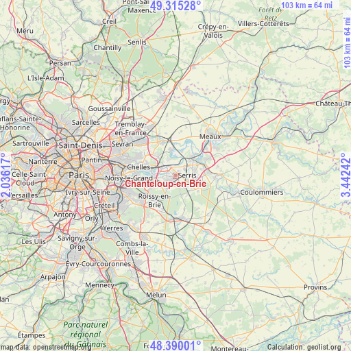
Chanteloup-en-Brie GPS coordinates[2]
48° 51' 17.208" North, 2° 44' 21.444" East
| Map corner | latitude | longitude |
|---|---|---|
| Upper-left | 49.31528°, | 2.03617° |
| Center: | 48.85478°, | 2.73929° |
| Lower-right: | 48.39001°, | 3.44242° |
| Map W x H: | 102.9×102.9 km | = 63.9×63.9mi |
| max Lat: | 51.07786° ⇑23.3% North |
| Chanteloup-en-Brie: | 48.85478° |
| min Lat: | ⇓76.7% South 41.3874° |
| min Long | Chanteloup-en-B | max Long |
| -5.08615° | 2.73929° | 9.52242° |
| W 54.1%⇐ | ⇒45.9% E |
Elevation
Elevation of Chanteloup-en-Brie is 120 m = 394 ft, and this is 73.7 m = 242 ft below average elevation for this country.
| Max E: |
2333 m = 7654 ft | 53.8% |
| Avg. | 193.7 m = 635 ft | |
| Chanteloup-en-Brie | 120 m = 394 ft | |
Min E: |
-1 m = -3 ft | 46.2% |
See also: France elevation on elevation.city.
Geographical zone
Chanteloup-en-Brie is located in North temperate zone (between Tropic of Cancer and the Arctic Circle). Distance of this North polar circle is 1969 km =1223.5 mi to North.| Distance of | km | miles | from Chanteloup-en-Brie |
|---|---|---|---|
| North Pole | 4574.9 | 2842.7 | to North |
| Arctic Circle | 1969 | 1223.5 | to North |
| Tropic Cancer | 2826.2 | 1756.1 | to South |
| Equator | 5432.1 | 3375.3 | to South |


Nearby cities:
15 places around Chanteloup-en-Brie: (largest is in red/bold)
• Bussy-Saint-Georges
3.2 km =2 mi,  240°
240°
• Bussy-Saint-Martin
3.6 km =2.2 mi,  259°
259°
• Chalifert
4.6 km =2.9 mi,  32°
32°
• Chessy
3.8 km =2.4 mi, 32°
• Conches-sur-Gondoire
1.6 km =1 mi,  275°
275°
• Dampmart
3.8 km =2.4 mi,  1°
1°
• Ferrières-en-Brie
4.2 km =2.6 mi,  214°
214°
• Gouvernes
3.6 km =2.2 mi, 279°
• Guermantes
2.5 km =1.6 mi,  265°
265°
• Jossigny
2.2 km =1.4 mi,  149°
149°
• Lagny-sur-Marne
2.1 km =1.3 mi,  308°
308°
• Montévrain
2.3 km =1.4 mi,  21°
21°
• Saint-Thibault-des-Vignes
4.7 km =2.9 mi,  292°
292°
• Serris
3.6 km =2.2 mi,  107°
107°
• Thorigny-sur-Marne
3.9 km =2.4 mi,  336°
336°
Sources, notices
• [Note1] Compared only with cities in France existing in our database
• [Src1] Map data: © OpenStreetMap contributors (CC-BY-SA)
• [Src2] Other city data from geonames.org with taken over terms of usage.
• [Src3] Geographical zone / Annual Mean Temperature by Robert A. Rohde @ Wikipedia
