Théziers geodata
Théziers (Occitanie) is a populated place; located in France in Europe/Paris (GMT+2) time zone. With population of 959 people, there are 9134 cities with bigger population in this country. Compared to other cities in France, 88% of cities are located further ↑North; 73% of cities are located further ←West and 89.1% of cities have higher elevation than Théziers. Note1
Administrative division(s):
- Level 1: Occitanie
- Level 2: Gard
- Level 3: Arrondissement de Nîmes
- Level 4: Théziers


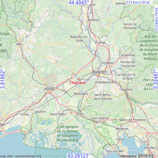
Théziers GPS coordinates[2]
43° 54' 0.072" North, 4° 37' 18.3" East
| Map corner | latitude | longitude |
|---|---|---|
| Upper-left | 44.4045°, | 3.91862° |
| Center: | 43.90002°, | 4.62175° |
| Lower-right: | 43.39123°, | 5.32487° |
| Map W x H: | 112.7×112.7 km | = 70×70mi |
| max Lat: | 51.07786° ⇑88% North |
| Théziers: | 43.90002° |
| min Lat: | ⇓12% South 41.3874° |
| min Long | Théziers | max Long |
| -5.08615° | 4.62175° | 9.52242° |
| W 73%⇐ | ⇒27% E |
Elevation
Elevation of Théziers is 32 m = 105 ft, and this is 161.7 m = 531 ft below average elevation for this country.
| Max E: |
2333 m = 7654 ft | 89.1% |
| Avg. | 193.7 m = 635 ft | |
| Théziers | 32 m = 105 ft | |
Min E: |
-1 m = -3 ft | 10.9% |
See also: France elevation on elevation.city.
Geographical zone
Théziers is located in North temperate zone (between Tropic of Cancer and the Arctic Circle). Distance of this Northern Tropic circle is 2275.3 km =1413.8 mi to South.| Distance of | km | miles | from Théziers |
|---|---|---|---|
| North Pole | 5125.8 | 3185 | to North |
| Arctic Circle | 2519.9 | 1565.8 | to North |
| Tropic Cancer | 2275.3 | 1413.8 | to South |
| Equator | 4881.2 | 3033 | to South |


Nearby cities:
15 places around Théziers: (largest is in red/bold)
• Aramon
4.8 km =3 mi,  100°
100°
• Boulbon
7.1 km =4.4 mi,  125°
125°
• Castillon-du-Gard
9 km =5.6 mi,  322°
322°
• Comps
5.4 km =3.4 mi,  193°
193°
• Domazan
3.9 km =2.4 mi,  35°
35°
• Fournès
3.1 km =1.9 mi,  331°
331°
• Jonquières-Saint-Vincent
9.3 km =5.8 mi,  210°
210°
• Lédenon
8.7 km =5.4 mi,  279°
279°
• Meynes
5.5 km =3.4 mi,  245°
245°
• Montfrin
3.2 km =2 mi, 213°
• Remoulins
6.1 km =3.8 mi, 315°
• Saint-Bonnet-du-Gard
6.8 km =4.2 mi,  295°
295°
• Saze
6.8 km =4.2 mi, 44°
• Sernhac
5.8 km =3.6 mi, 282°
• Vallabrègues
5.2 km =3.2 mi,  175°
175°
Sources, notices
• [Note1] Compared only with cities in France existing in our database
• [Src1] Map data: © OpenStreetMap contributors (CC-BY-SA)
• [Src2] Other city data from geonames.org with taken over terms of usage.
• [Src3] Geographical zone / Annual Mean Temperature by Robert A. Rohde @ Wikipedia
