Domazan geodata
Domazan (Occitanie) is a populated place; located in France in Europe/Paris (GMT+2) time zone. With population of 831 people, there are 10280 cities with bigger population in this country. Compared to other cities in France, 87.8% of cities are located further ↑North; 73.3% of cities are located further ←West and 72.3% of cities have higher elevation than Domazan. Note1
Administrative division(s):
- Level 1: Occitanie
- Level 2: Gard
- Level 3: Arrondissement de Nîmes
- Level 4: Domazan


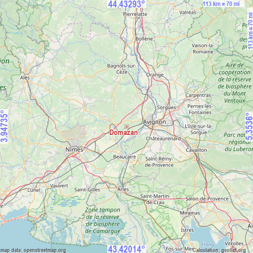
Domazan GPS coordinates[2]
43° 55' 43.284" North, 4° 39' 1.728" East
| Map corner | latitude | longitude |
|---|---|---|
| Upper-left | 44.43293°, | 3.94735° |
| Center: | 43.92869°, | 4.65048° |
| Lower-right: | 43.42014°, | 5.3536° |
| Map W x H: | 112.6×112.6 km | = 70×70mi |
| max Lat: | 51.07786° ⇑87.8% North |
| Domazan: | 43.92869° |
| min Lat: | ⇓12.2% South 41.3874° |
| min Long | Domazan | max Long |
| -5.08615° | 4.65048° | 9.52242° |
| W 73.3%⇐ | ⇒26.7% E |
Elevation
Elevation of Domazan is 73 m = 240 ft, and this is 120.7 m = 396 ft below average elevation for this country.
| Max E: |
2333 m = 7654 ft | 72.3% |
| Avg. | 193.7 m = 635 ft | |
| Domazan | 73 m = 240 ft | |
Min E: |
-1 m = -3 ft | 27.7% |
See also: France elevation on elevation.city.
Geographical zone
Domazan is located in North temperate zone (between Tropic of Cancer and the Arctic Circle). Distance of this Northern Tropic circle is 2278.5 km =1415.8 mi to South.| Distance of | km | miles | from Domazan |
|---|---|---|---|
| North Pole | 5122.6 | 3183 | to North |
| Arctic Circle | 2516.8 | 1563.9 | to North |
| Tropic Cancer | 2278.5 | 1415.8 | to South |
| Equator | 4884.4 | 3035 | to South |


Nearby cities:
15 places around Domazan: (largest is in red/bold)
• Aramon
4.8 km =3 mi,  149°
149°
• Barbentane
8.4 km =5.2 mi,  112°
112°
• Boulbon
8.2 km =5.1 mi, 154°
• Castillon-du-Gard
8.7 km =5.4 mi,  297°
297°
• Comps
9.1 km =5.7 mi,  203°
203°
• Fournès
3.8 km =2.4 mi,  263°
263°
• Meynes
9.1 km =5.7 mi,  233°
233°
• Montfrin
7.1 km =4.4 mi,  214°
214°
• Remoulins
6.7 km =4.2 mi,  280°
280°
• Rochefort-du-Gard
6.2 km =3.9 mi,  30°
30°
• Saint-Bonnet-du-Gard
8.4 km =5.2 mi,  267°
267°
• Saze
2.9 km =1.8 mi,  56°
56°
• Sernhac
8.2 km =5.1 mi, 256°
• Théziers
3.9 km =2.4 mi,  215°
215°
• Vallabrègues
8.6 km =5.3 mi,  192°
192°
Sources, notices
• [Note1] Compared only with cities in France existing in our database
• [Src1] Map data: © OpenStreetMap contributors (CC-BY-SA)
• [Src2] Other city data from geonames.org with taken over terms of usage.
• [Src3] Geographical zone / Annual Mean Temperature by Robert A. Rohde @ Wikipedia
