Lédenon geodata
Lédenon (Occitanie) is a populated place; located in France in Europe/Paris (GMT+2) time zone. With population of 1,225 people, there are 7409 cities with bigger population in this country. Compared to other cities in France, 87.9% of cities are located further ↑North; 72.2% of cities are located further ←West and 53.3% of cities have higher elevation than Lédenon. Note1
Administrative division(s):
- Level 1: Occitanie
- Level 2: Gard
- Level 3: Arrondissement de Nîmes
- Level 4: Lédenon


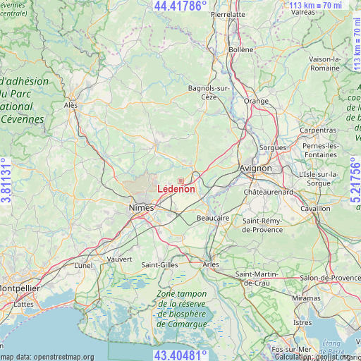
Lédenon GPS coordinates[2]
43° 54' 48.564" North, 4° 30' 51.984" East
| Map corner | latitude | longitude |
|---|---|---|
| Upper-left | 44.41786°, | 3.81131° |
| Center: | 43.91349°, | 4.51444° |
| Lower-right: | 43.40481°, | 5.21756° |
| Map W x H: | 112.6×112.6 km | = 70×70mi |
| max Lat: | 51.07786° ⇑87.9% North |
| Lédenon: | 43.91349° |
| min Lat: | ⇓12.1% South 41.3874° |
| min Long | Lédenon | max Long |
| -5.08615° | 4.51444° | 9.52242° |
| W 72.2%⇐ | ⇒27.8% E |
Elevation
Elevation of Lédenon is 121 m = 397 ft, and this is 72.7 m = 239 ft below average elevation for this country.
| Max E: |
2333 m = 7654 ft | 53.3% |
| Avg. | 193.7 m = 635 ft | |
| Lédenon | 121 m = 397 ft | |
Min E: |
-1 m = -3 ft | 46.7% |
See also: France elevation on elevation.city.
Geographical zone
Lédenon is located in North temperate zone (between Tropic of Cancer and the Arctic Circle). Distance of this Northern Tropic circle is 2276.8 km =1414.7 mi to South.| Distance of | km | miles | from Lédenon |
|---|---|---|---|
| North Pole | 5124.3 | 3184.1 | to North |
| Arctic Circle | 2518.5 | 1564.9 | to North |
| Tropic Cancer | 2276.8 | 1414.7 | to South |
| Equator | 4882.7 | 3034 | to South |


Nearby cities:
15 places around Lédenon: (largest is in red/bold)
• Bezouce
4 km =2.5 mi,  208°
208°
• Cabrières
3.6 km =2.2 mi,  252°
252°
• Castillon-du-Gard
6.5 km =4 mi,  28°
28°
• Collias
5.5 km =3.4 mi,  327°
327°
• Fournès
7.2 km =4.5 mi,  80°
80°
• Marguerittes
8.2 km =5.1 mi,  222°
222°
• Meynes
5.2 km =3.2 mi,  136°
136°
• Montfrin
8 km =5 mi,  121°
121°
• Poulx
7.9 km =4.9 mi,  265°
265°
• Remoulins
5.2 km =3.2 mi,  56°
56°
• Saint-Bonnet-du-Gard
2.8 km =1.7 mi, 60°
• Saint-Gervasy
5.6 km =3.5 mi, 223°
• Sernhac
2.9 km =1.8 mi,  95°
95°
• Théziers
8.7 km =5.4 mi, 99°
• Vers-Pont-du-Gard
6.1 km =3.8 mi,  14°
14°
Sources, notices
• [Note1] Compared only with cities in France existing in our database
• [Src1] Map data: © OpenStreetMap contributors (CC-BY-SA)
• [Src2] Other city data from geonames.org with taken over terms of usage.
• [Src3] Geographical zone / Annual Mean Temperature by Robert A. Rohde @ Wikipedia
