Thénezay geodata
Thénezay (Nouvelle-Aquitaine) is a populated place; located in France in Europe/Paris (GMT+2) time zone. With population of 1,474 people, there are 6280 cities with bigger population in this country. Compared to other cities in France, 58.1% of cities are located further ↑North; 78.3% of cities are located further →East and 51.4% of cities have lower elevation than Thénezay. Note1
Administrative division(s):
- Level 1: Nouvelle-Aquitaine
- Level 2: Département des Deux-Sèvres
- Level 3: Arrondissement de Parthenay
- Level 4: Thénezay


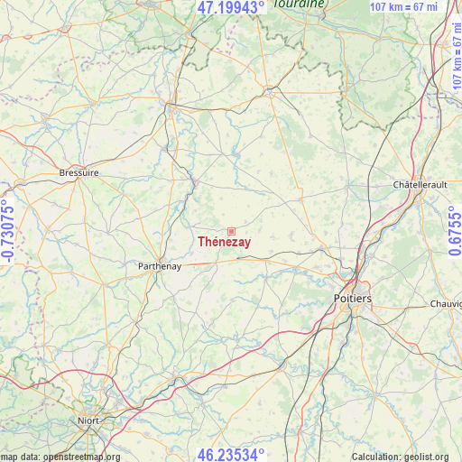
Thénezay GPS coordinates[2]
46° 43' 10.344" North, 0° 1' 39.468" West
| Map corner | latitude | longitude |
|---|---|---|
| Upper-left | 47.19943°, | -0.73075° |
| Center: | 46.71954°, | -0.02763° |
| Lower-right: | 46.23534°, | 0.6755° |
| Map W x H: | 107.2×107.2 km | = 66.6×66.6mi |
| max Lat: | 51.07786° ⇑58.1% North |
| Thénezay: | 46.71954° |
| min Lat: | ⇓41.9% South 41.3874° |
| min Long | Thénezay | max Long |
| -5.08615° | -0.02763° | 9.52242° |
| W 21.7%⇐ | ⇒78.3% E |
Elevation
Elevation of Thénezay is 137 m = 449 ft, and this is 56.7 m = 186 ft below average elevation for this country.
| Max E: |
2333 m = 7654 ft | 48.6% |
| Avg. | 193.7 m = 635 ft | |
| Thénezay | 137 m = 449 ft | |
Min E: |
-1 m = -3 ft | 51.4% |
See also: France elevation on elevation.city.
Geographical zone
Thénezay is located in North temperate zone (between Tropic of Cancer and the Arctic Circle). Distance of this North polar circle is 2206.4 km =1371 mi to North.| Distance of | km | miles | from Thénezay |
|---|---|---|---|
| North Pole | 4812.3 | 2990.2 | to North |
| Arctic Circle | 2206.4 | 1371 | to North |
| Tropic Cancer | 2588.8 | 1608.6 | to South |
| Equator | 5194.7 | 3227.8 | to South |


Nearby cities:
15 places around Thénezay: (largest is in red/bold)
• Airvault
14.6 km =9.1 mi,  324°
324°
• Assais-les-Jumeaux
7.3 km =4.5 mi,  346°
346°
• Ayron
10.2 km =6.3 mi,  130°
130°
• Chalandray
6.7 km =4.2 mi,  163°
163°
• Champigny-le-Sec
14 km =8.7 mi,  91°
91°
• Cherves
3.4 km =2.1 mi, 92°
• Chiré-en-Montreuil
14.8 km =9.2 mi, 127°
• Gourgé
10.7 km =6.6 mi,  275°
275°
• La Ferrière-en-Parthenay
7.9 km =4.9 mi,  208°
208°
• La Peyratte
10.5 km =6.5 mi,  241°
241°
• Latillé
13.6 km =8.5 mi,  144°
144°
• Le Rochereau
13.9 km =8.6 mi,  95°
95°
• Louin
13.7 km =8.5 mi,  312°
312°
• Saint-Jean-de-Sauves
16.3 km =10.1 mi,  34°
34°
• Vasles
16 km =9.9 mi,  179°
179°
Sources, notices
• [Note1] Compared only with cities in France existing in our database
• [Src1] Map data: © OpenStreetMap contributors (CC-BY-SA)
• [Src2] Other city data from geonames.org with taken over terms of usage.
• [Src3] Geographical zone / Annual Mean Temperature by Robert A. Rohde @ Wikipedia
