Louin geodata
Louin (Nouvelle-Aquitaine) is a populated place; located in France in Europe/Paris (GMT+2) time zone. With population of 719 people, there are 11547 cities with bigger population in this country. Compared to other cities in France, 57.2% of cities are located further ↑North; 79.3% of cities are located further →East and 65.3% of cities have higher elevation than Louin. Note1
Administrative division(s):
- Level 1: Nouvelle-Aquitaine
- Level 2: Département des Deux-Sèvres
- Level 3: Arrondissement de Parthenay
- Level 4: Louin


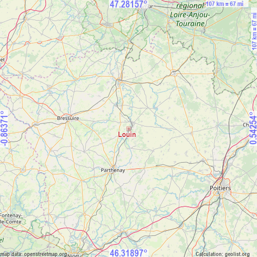
Louin GPS coordinates[2]
46° 48' 8.712" North, 0° 9' 38.088" West
| Map corner | latitude | longitude |
|---|---|---|
| Upper-left | 47.28157°, | -0.86371° |
| Center: | 46.80242°, | -0.16058° |
| Lower-right: | 46.31897°, | 0.54254° |
| Map W x H: | 107×107 km | = 66.5×66.5mi |
| max Lat: | 51.07786° ⇑57.2% North |
| Louin: | 46.80242° |
| min Lat: | ⇓42.8% South 41.3874° |
| min Long | Louin | max Long |
| -5.08615° | -0.16058° | 9.52242° |
| W 20.7%⇐ | ⇒79.3% E |
Elevation
Elevation of Louin is 89 m = 292 ft, and this is 104.7 m = 344 ft below average elevation for this country.
| Max E: |
2333 m = 7654 ft | 65.3% |
| Avg. | 193.7 m = 635 ft | |
| Louin | 89 m = 292 ft | |
Min E: |
-1 m = -3 ft | 34.7% |
See also: France elevation on elevation.city.
Geographical zone
Louin is located in North temperate zone (between Tropic of Cancer and the Arctic Circle). Distance of this North polar circle is 2197.2 km =1365.3 mi to North.| Distance of | km | miles | from Louin |
|---|---|---|---|
| North Pole | 4803.1 | 2984.5 | to North |
| Arctic Circle | 2197.2 | 1365.3 | to North |
| Tropic Cancer | 2598 | 1614.3 | to South |
| Equator | 5203.9 | 3233.6 | to South |


Nearby cities:
15 places around Louin: (largest is in red/bold)
• Airvault
3.2 km =2 mi,  32°
32°
• Amailloux
13.4 km =8.3 mi,  242°
242°
• Assais-les-Jumeaux
8.7 km =5.4 mi,  104°
104°
• Chiché
15.2 km =9.4 mi,  267°
267°
• Faye-l’Abbesse
14.9 km =9.3 mi,  281°
281°
• Glénay
9.4 km =5.8 mi,  312°
312°
• Gourgé
8.3 km =5.2 mi,  183°
183°
• La Peyratte
14.3 km =8.9 mi, 176°
• Luzay
13.7 km =8.5 mi,  348°
348°
• Moncontour
14 km =8.7 mi,  50°
50°
• Saint-Jouin-de-Marnes
11.8 km =7.3 mi,  42°
42°
• Saint-Varent
11.1 km =6.9 mi,  330°
330°
• Taizé
14.1 km =8.8 mi,  14°
14°
• Thénezay
13.7 km =8.5 mi,  132°
132°
• Viennay
14 km =8.7 mi,  207°
207°
Sources, notices
• [Note1] Compared only with cities in France existing in our database
• [Src1] Map data: © OpenStreetMap contributors (CC-BY-SA)
• [Src2] Other city data from geonames.org with taken over terms of usage.
• [Src3] Geographical zone / Annual Mean Temperature by Robert A. Rohde @ Wikipedia
