Targon geodata
Targon (Nouvelle-Aquitaine) is a populated place; located in France in Europe/Paris (GMT+2) time zone. With population of 1,837 people, there are 5161 cities with bigger population in this country. Compared to other cities in France, 81.9% of cities are located further ↑North; 80.4% of cities are located further →East and 74.6% of cities have higher elevation than Targon. Note1
Administrative division(s):
- Level 1: Nouvelle-Aquitaine
- Level 2: Gironde
- Level 3: Arrondissement de Langon
- Level 4: Targon


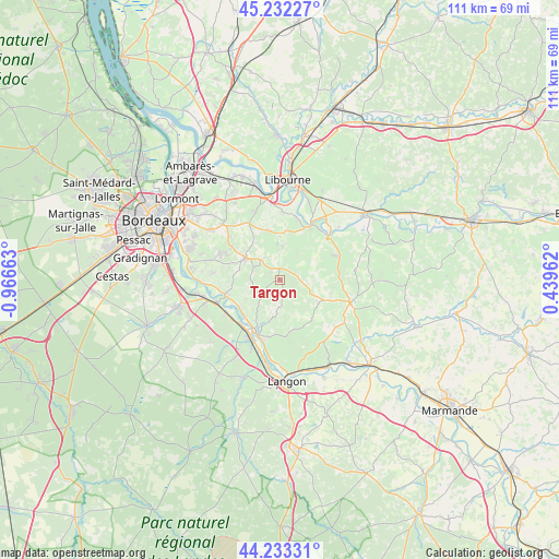
Targon GPS coordinates[2]
44° 44' 5.82" North, 0° 15' 48.636" West
| Map corner | latitude | longitude |
|---|---|---|
| Upper-left | 45.23227°, | -0.96663° |
| Center: | 44.73495°, | -0.26351° |
| Lower-right: | 44.23331°, | 0.43962° |
| Map W x H: | 111.1×111.1 km | = 69×69mi |
| max Lat: | 51.07786° ⇑81.9% North |
| Targon: | 44.73495° |
| min Lat: | ⇓18.1% South 41.3874° |
| min Long | Targon | max Long |
| -5.08615° | -0.26351° | 9.52242° |
| W 19.6%⇐ | ⇒80.4% E |
Elevation
Elevation of Targon is 68 m = 223 ft, and this is 125.7 m = 412 ft below average elevation for this country.
| Max E: |
2333 m = 7654 ft | 74.6% |
| Avg. | 193.7 m = 635 ft | |
| Targon | 68 m = 223 ft | |
Min E: |
-1 m = -3 ft | 25.4% |
See also: France elevation on elevation.city.
Geographical zone
Targon is located in North temperate zone (between Tropic of Cancer and the Arctic Circle). Distance of this Northern Tropic circle is 2368.1 km =1471.5 mi to South.| Distance of | km | miles | from Targon |
|---|---|---|---|
| North Pole | 5033 | 3127.4 | to North |
| Arctic Circle | 2427.1 | 1508.1 | to North |
| Tropic Cancer | 2368.1 | 1471.5 | to South |
| Equator | 4974.1 | 3090.8 | to South |


Nearby cities:
15 places around Targon: (largest is in red/bold)
• Baron
10.4 km =6.5 mi,  338°
338°
• Capian
5.9 km =3.7 mi,  242°
242°
• Créon
8 km =5 mi,  303°
303°
• Espiet
7.7 km =4.8 mi,  0°
0°
• Frontenac
8 km =5 mi,  87°
87°
• Grézillac
10 km =6.2 mi,  21°
21°
• Haux
8.4 km =5.2 mi,  270°
270°
• La Sauve
5.5 km =3.4 mi,  310°
310°
• Langoiran
10.7 km =6.6 mi,  254°
254°
• Lestiac-sur-Garonne
9.9 km =6.2 mi, 242°
• Naujan-et-Postiac
8.9 km =5.5 mi,  47°
47°
• Nérigean
11.1 km =6.9 mi,  351°
351°
• Paillet
9.7 km =6 mi, 235°
• Rions
10.5 km =6.5 mi,  221°
221°
• Saint-Quentin-de-Baron
9.4 km =5.8 mi, 348°
Sources, notices
• [Note1] Compared only with cities in France existing in our database
• [Src1] Map data: © OpenStreetMap contributors (CC-BY-SA)
• [Src2] Other city data from geonames.org with taken over terms of usage.
• [Src3] Geographical zone / Annual Mean Temperature by Robert A. Rohde @ Wikipedia
