Espiet geodata
Espiet (Nouvelle-Aquitaine) is a populated place; located in France in Europe/Paris (GMT+2) time zone. With population of 581 people, there are 13635 cities with bigger population in this country. Compared to other cities in France, 81.4% of cities are located further ↑North; 80.4% of cities are located further →East and 78.2% of cities have higher elevation than Espiet. Note1
Administrative division(s):
- Level 1: Nouvelle-Aquitaine
- Level 2: Gironde
- Level 3: Arrondissement de Libourne
- Level 4: Espiet


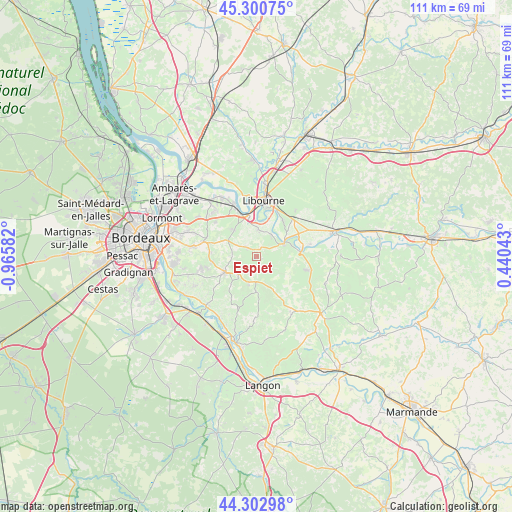
Espiet GPS coordinates[2]
44° 48' 14.472" North, 0° 15' 45.72" West
| Map corner | latitude | longitude |
|---|---|---|
| Upper-left | 45.30075°, | -0.96582° |
| Center: | 44.80402°, | -0.2627° |
| Lower-right: | 44.30298°, | 0.44043° |
| Map W x H: | 110.9×110.9 km | = 68.9×68.9mi |
| max Lat: | 51.07786° ⇑81.4% North |
| Espiet: | 44.80402° |
| min Lat: | ⇓18.6% South 41.3874° |
| min Long | Espiet | max Long |
| -5.08615° | -0.2627° | 9.52242° |
| W 19.6%⇐ | ⇒80.4% E |
Elevation
Elevation of Espiet is 59 m = 194 ft, and this is 134.7 m = 442 ft below average elevation for this country.
| Max E: |
2333 m = 7654 ft | 78.2% |
| Avg. | 193.7 m = 635 ft | |
| Espiet | 59 m = 194 ft | |
Min E: |
-1 m = -3 ft | 21.8% |
See also: France elevation on elevation.city.
Geographical zone
Espiet is located in North temperate zone (between Tropic of Cancer and the Arctic Circle). Distance of this Northern Tropic circle is 2375.8 km =1476.3 mi to South.| Distance of | km | miles | from Espiet |
|---|---|---|---|
| North Pole | 5025.3 | 3122.6 | to North |
| Arctic Circle | 2419.4 | 1503.3 | to North |
| Tropic Cancer | 2375.8 | 1476.3 | to South |
| Equator | 4981.7 | 3095.5 | to South |


Nearby cities:
15 places around Espiet: (largest is in red/bold)
• Arveyres
9 km =5.6 mi,  349°
349°
• Baron
4.4 km =2.7 mi,  296°
296°
• Branne
7.1 km =4.4 mi,  62°
62°
• Camarsac
8.5 km =5.3 mi,  291°
291°
• Créon
7.5 km =4.7 mi,  244°
244°
• Grézillac
4 km =2.5 mi,  67°
67°
• Génissac
5.2 km =3.2 mi,  11°
11°
• La Sauve
5.9 km =3.7 mi,  225°
225°
• Moulon
6.3 km =3.9 mi,  35°
35°
• Naujan-et-Postiac
6.7 km =4.2 mi,  104°
104°
• Nérigean
3.6 km =2.2 mi,  333°
333°
• Saint-Germain-du-Puch
6.7 km =4.2 mi,  320°
320°
• Saint-Quentin-de-Baron
2.4 km =1.5 mi,  309°
309°
• Targon
7.7 km =4.8 mi,  180°
180°
• Vignonet
9.1 km =5.7 mi, 55°
Sources, notices
• [Note1] Compared only with cities in France existing in our database
• [Src1] Map data: © OpenStreetMap contributors (CC-BY-SA)
• [Src2] Other city data from geonames.org with taken over terms of usage.
• [Src3] Geographical zone / Annual Mean Temperature by Robert A. Rohde @ Wikipedia
