Saint-Quentin-de-Baron geodata
Saint-Quentin-de-Baron (Nouvelle-Aquitaine) is a populated place; located in France in Europe/Paris (GMT+2) time zone. With population of 1,043 people, there are 8513 cities with bigger population in this country. Compared to other cities in France, 81.3% of cities are located further ↑North; 80.7% of cities are located further →East and 78.6% of cities have higher elevation than Saint-Quentin-de-Baron. Note1
Administrative division(s):
- Level 1: Nouvelle-Aquitaine
- Level 2: Gironde
- Level 3: Arrondissement de Libourne
- Level 4: Saint-Quentin-de-Baron
Current local time in Saint-Quentin-de-Baron:
09:54 AM, SaturdayDifference from your time zone: hours


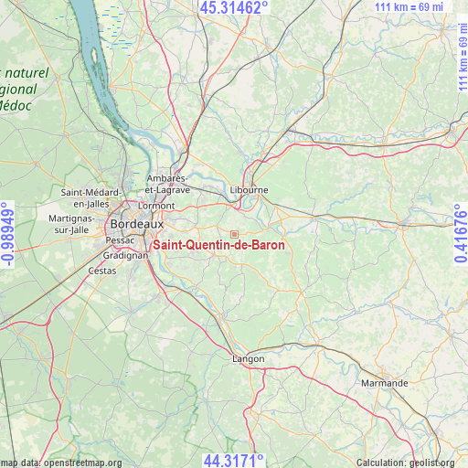
Saint-Quentin-de-Baron GPS coordinates[2]
44° 49' 4.872" North, 0° 17' 10.896" West
| Map corner | latitude | longitude |
|---|---|---|
| Upper-left | 45.31462°, | -0.98949° |
| Center: | 44.81802°, | -0.28636° |
| Lower-right: | 44.3171°, | 0.41676° |
| Map W x H: | 110.9×110.9 km | = 68.9×68.9mi |
| max Lat: | 51.07786° ⇑81.3% North |
| Saint-Quentin-de-Baron: | 44.81802° |
| min Lat: | ⇓18.7% South 41.3874° |
| min Long | Saint-Quentin-d | max Long |
| -5.08615° | -0.28636° | 9.52242° |
| W 19.3%⇐ | ⇒80.7% E |
Elevation
Elevation of Saint-Quentin-de-Baron is 58 m = 190 ft, and this is 135.7 m = 445 ft below average elevation for this country.
| Max E: |
2333 m = 7654 ft | 78.6% |
| Avg. | 193.7 m = 635 ft | |
| Saint-Quentin-de-Baron | 58 m = 190 ft | |
Min E: |
-1 m = -3 ft | 21.4% |
See also: France elevation on elevation.city.
Geographical zone
Saint-Quentin-de-Baron is located in North temperate zone (between Tropic of Cancer and the Arctic Circle). Distance of this Northern Tropic circle is 2377.4 km =1477.2 mi to South.| Distance of | km | miles | from Saint-Quentin-de-Baron |
|---|---|---|---|
| North Pole | 5023.8 | 3121.6 | to North |
| Arctic Circle | 2417.9 | 1502.4 | to North |
| Tropic Cancer | 2377.4 | 1477.2 | to South |
| Equator | 4983.3 | 3096.5 | to South |


Nearby cities:
15 places around Saint-Quentin-de-Baron: (largest is in red/bold)
• Arveyres
7.3 km =4.5 mi,  1°
1°
• Baron
2.1 km =1.3 mi,  281°
281°
• Branne
8.3 km =5.2 mi,  78°
78°
• Camarsac
6.3 km =3.9 mi, 284°
• Créon
6.9 km =4.3 mi,  225°
225°
• Espiet
2.4 km =1.5 mi,  129°
129°
• Grézillac
5.5 km =3.4 mi,  90°
90°
• Génissac
4.6 km =2.9 mi,  38°
38°
• La Sauve
6.2 km =3.9 mi,  202°
202°
• Loupes
8.1 km =5 mi,  263°
263°
• Moulon
6.5 km =4 mi,  57°
57°
• Naujan-et-Postiac
8.9 km =5.5 mi,  111°
111°
• Nérigean
1.7 km =1.1 mi,  7°
7°
• Saint-Germain-du-Puch
4.3 km =2.7 mi,  326°
326°
• Sallebœuf
9.1 km =5.7 mi, 280°
Sources, notices
• [Note1] Compared only with cities in France existing in our database
• [Src1] Map data: © OpenStreetMap contributors (CC-BY-SA)
• [Src2] Other city data from geonames.org with taken over terms of usage.
• [Src3] Geographical zone / Annual Mean Temperature by Robert A. Rohde @ Wikipedia
