Sury-aux-Bois geodata
Sury-aux-Bois (Centre) is a populated place; located in France in Europe/Paris (GMT+2) time zone. With population of 541 people, there are 14367 cities with bigger population in this country. Compared to other cities in France, 58.7% of cities are located further ↓South; 52% of cities are located further →East and 51.2% of cities have higher elevation than Sury-aux-Bois. Note1
Administrative division(s):
- Level 1: Centre
- Level 2: Loiret
- Level 3: Arrondissement d’Orléans
- Level 4: Sury-aux-Bois


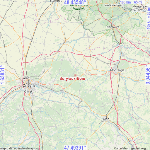
Sury-aux-Bois GPS coordinates[2]
47° 58' 0.624" North, 2° 20' 29.148" East
| Map corner | latitude | longitude |
|---|---|---|
| Upper-left | 48.43548°, | 1.63831° |
| Center: | 47.96684°, | 2.34143° |
| Lower-right: | 47.49391°, | 3.04456° |
| Map W x H: | 104.7×104.7 km | = 65.1×65.1mi |
| max Lat: | 51.07786° ⇑41.3% North |
| Sury-aux-Bois: | 47.96684° |
| min Lat: | ⇓58.7% South 41.3874° |
| min Long | Sury-aux-Bois | max Long |
| -5.08615° | 2.34143° | 9.52242° |
| W 48%⇐ | ⇒52% E |
Elevation
Elevation of Sury-aux-Bois is 128 m = 420 ft, and this is 65.7 m = 216 ft below average elevation for this country.
| Max E: |
2333 m = 7654 ft | 51.2% |
| Avg. | 193.7 m = 635 ft | |
| Sury-aux-Bois | 128 m = 420 ft | |
Min E: |
-1 m = -3 ft | 48.8% |
See also: France elevation on elevation.city.
Geographical zone
Sury-aux-Bois is located in North temperate zone (between Tropic of Cancer and the Arctic Circle). Distance of this North polar circle is 2067.8 km =1284.9 mi to North.| Distance of | km | miles | from Sury-aux-Bois |
|---|---|---|---|
| North Pole | 4673.6 | 2904 | to North |
| Arctic Circle | 2067.8 | 1284.9 | to North |
| Tropic Cancer | 2727.5 | 1694.8 | to South |
| Equator | 5333.4 | 3314 | to South |


Nearby cities:
15 places around Sury-aux-Bois: (largest is in red/bold)
• Beaune-la-Rolande
13.4 km =8.3 mi,  29°
29°
• Bellegarde
7.1 km =4.4 mi,  74°
74°
• Boiscommun
8.3 km =5.2 mi,  22°
22°
• Bouzy-la-Forêt
13.1 km =8.1 mi,  168°
168°
• Chailly-en-Gâtinais
15.2 km =9.4 mi,  98°
98°
• Chambon-la-Forêt
10.6 km =6.6 mi,  340°
340°
• Châteauneuf-sur-Loire
14.5 km =9 mi,  219°
219°
• Germigny-des-Prés
14.6 km =9.1 mi,  201°
201°
• Ladon
15.1 km =9.4 mi, 74°
• Lorris
15.5 km =9.6 mi,  123°
123°
• Nibelle
6.2 km =3.9 mi,  350°
350°
• Noyers
14.8 km =9.2 mi,  113°
113°
• Quiers-sur-Bézonde
8.1 km =5 mi, 66°
• Vitry-aux-Loges
6.7 km =4.2 mi,  236°
236°
• Vrigny
14.3 km =8.9 mi,  331°
331°
Sources, notices
• [Note1] Compared only with cities in France existing in our database
• [Src1] Map data: © OpenStreetMap contributors (CC-BY-SA)
• [Src2] Other city data from geonames.org with taken over terms of usage.
• [Src3] Geographical zone / Annual Mean Temperature by Robert A. Rohde @ Wikipedia
