Lorris geodata
Lorris (Centre) is a populated place; located in France in Europe/Paris (GMT+2) time zone. With population of 2,883 people, there are 3383 cities with bigger population in this country. Compared to other cities in France, 57.4% of cities are located further ↓South; 50.9% of cities are located further ←West and 52.6% of cities have higher elevation than Lorris. Note1
Administrative division(s):
- Level 1: Centre
- Level 2: Loiret
- Level 3: Arrondissement de Montargis
- Level 4: Lorris


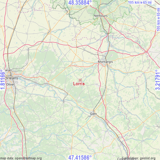
Lorris GPS coordinates[2]
47° 53' 22.2" North, 2° 30' 53.208" East
| Map corner | latitude | longitude |
|---|---|---|
| Upper-left | 48.35884°, | 1.81166° |
| Center: | 47.8895°, | 2.51478° |
| Lower-right: | 47.41586°, | 3.21791° |
| Map W x H: | 104.8×104.8 km | = 65.1×65.1mi |
| max Lat: | 51.07786° ⇑42.6% North |
| Lorris: | 47.8895° |
| min Lat: | ⇓57.4% South 41.3874° |
| min Long | Lorris | max Long |
| -5.08615° | 2.51478° | 9.52242° |
| W 50.9%⇐ | ⇒49.1% E |
Elevation
Elevation of Lorris is 123 m = 404 ft, and this is 70.7 m = 232 ft below average elevation for this country.
| Max E: |
2333 m = 7654 ft | 52.6% |
| Avg. | 193.7 m = 635 ft | |
| Lorris | 123 m = 404 ft | |
Min E: |
-1 m = -3 ft | 47.4% |
See also: France elevation on elevation.city.
Geographical zone
Lorris is located in North temperate zone (between Tropic of Cancer and the Arctic Circle). Distance of this North polar circle is 2076.4 km =1290.2 mi to North.| Distance of | km | miles | from Lorris |
|---|---|---|---|
| North Pole | 4682.2 | 2909.4 | to North |
| Arctic Circle | 2076.4 | 1290.2 | to North |
| Tropic Cancer | 2718.9 | 1689.4 | to South |
| Equator | 5324.8 | 3308.7 | to South |


Nearby cities:
15 places around Lorris: (largest is in red/bold)
• Bellegarde
12.1 km =7.5 mi,  329°
329°
• Bouzy-la-Forêt
11.1 km =6.9 mi,  247°
247°
• Bray-en-Val
13 km =8.1 mi,  238°
238°
• Chailly-en-Gâtinais
6.7 km =4.2 mi,  18°
18°
• Changy-les-Bois
13.2 km =8.2 mi,  105°
105°
• Chevillon-sur-Huillard
11.6 km =7.2 mi,  45°
45°
• Dampierre-en-Burly
14.2 km =8.8 mi,  178°
178°
• Ladon
12.7 km =7.9 mi,  7°
7°
• Montereau
5.7 km =3.5 mi,  130°
130°
• Noyers
2.8 km =1.7 mi, 14°
• Ouzouer-sur-Loire
13.9 km =8.6 mi,  190°
190°
• Quiers-sur-Bézonde
13.1 km =8.1 mi,  335°
335°
• Saint-Maurice-sur-Fessard
13.9 km =8.6 mi,  34°
34°
• Thimory
7.4 km =4.6 mi,  60°
60°
• Villemoutiers
12.2 km =7.6 mi, 15°
Sources, notices
• [Note1] Compared only with cities in France existing in our database
• [Src1] Map data: © OpenStreetMap contributors (CC-BY-SA)
• [Src2] Other city data from geonames.org with taken over terms of usage.
• [Src3] Geographical zone / Annual Mean Temperature by Robert A. Rohde @ Wikipedia
