Sugères geodata
Sugères (Auvergne-Rhône-Alpes) is a populated place; located in France in Europe/Paris (GMT+2) time zone. With population of 536 people, there are 14480 cities with bigger population in this country. Compared to other cities in France, 72.5% of cities are located further ↑North; 63.3% of cities are located further ←West and 93% of cities have lower elevation than Sugères. Note1
Administrative division(s):
- Level 1: Auvergne-Rhône-Alpes
- Level 2: Département du Puy-de-Dôme
- Level 3: Issoire
- Level 4: Sugères


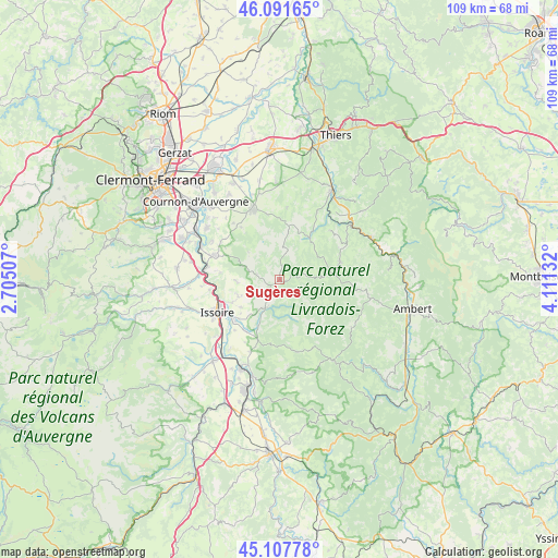
Sugères GPS coordinates[2]
45° 36' 6.732" North, 3° 24' 29.52" East
| Map corner | latitude | longitude |
|---|---|---|
| Upper-left | 46.09165°, | 2.70507° |
| Center: | 45.60187°, | 3.4082° |
| Lower-right: | 45.10778°, | 4.11132° |
| Map W x H: | 109.4×109.4 km | = 68×68mi |
| max Lat: | 51.07786° ⇑72.5% North |
| Sugères: | 45.60187° |
| min Lat: | ⇓27.5% South 41.3874° |
| min Long | Sugères | max Long |
| -5.08615° | 3.4082° | 9.52242° |
| W 63.3%⇐ | ⇒36.7% E |
Elevation
Elevation of Sugères is 504 m = 1654 ft, and this is 310.3 m = 1018 ft above average elevation for this country.
| Max E: |
2333 m = 7654 ft | 7% |
| Sugères | 504 m 1654 ft | |
| Avg. | 193.7 m = 635 ft | |
Min E: |
-1 m = -3 ft | 93% |
See also: France elevation on elevation.city.
Geographical zone
Sugères is located in North temperate zone (between Tropic of Cancer and the Arctic Circle). Distance of this North polar circle is 2330.7 km =1448.2 mi to North.| Distance of | km | miles | from Sugères |
|---|---|---|---|
| North Pole | 4936.6 | 3067.5 | to North |
| Arctic Circle | 2330.7 | 1448.2 | to North |
| Tropic Cancer | 2464.5 | 1531.4 | to South |
| Equator | 5070.5 | 3150.7 | to South |


Nearby cities:
15 places around Sugères: (largest is in red/bold)
• Cunlhat
12.2 km =7.6 mi,  74°
74°
• Issoire
14 km =8.7 mi,  242°
242°
• Laps
13.4 km =8.3 mi,  306°
306°
• Montaigut
3.5 km =2.2 mi, 65°
• Orbeil
11.1 km =6.9 mi,  246°
246°
• Parent
14.1 km =8.8 mi,  280°
280°
• Parentignat
11.9 km =7.4 mi,  230°
230°
• Saint-Babel
8.4 km =5.2 mi,  266°
266°
• Saint-Dier-d’Auvergne
10.1 km =6.3 mi,  35°
35°
• Saint-Julien-de-Coppel
12.8 km =8 mi,  323°
323°
• Sauxillanges
6.3 km =3.9 mi,  206°
206°
• Vernet-la-Varenne
14.5 km =9 mi,  166°
166°
• Vic-le-Comte
13.4 km =8.3 mi,  289°
289°
• Yronde
12 km =7.5 mi, 276°
• Égliseneuve-près-Billom
13.4 km =8.3 mi,  354°
354°
Sources, notices
• [Note1] Compared only with cities in France existing in our database
• [Src1] Map data: © OpenStreetMap contributors (CC-BY-SA)
• [Src2] Other city data from geonames.org with taken over terms of usage.
• [Src3] Geographical zone / Annual Mean Temperature by Robert A. Rohde @ Wikipedia
