Cunlhat geodata
Cunlhat (Auvergne-Rhône-Alpes) is a populated place; located in France in Europe/Paris (GMT+2) time zone. With population of 1,418 people, there are 6526 cities with bigger population in this country. Compared to other cities in France, 72.1% of cities are located further ↑North; 64.8% of cities are located further ←West and 97% of cities have lower elevation than Cunlhat. Note1
Administrative division(s):
- Level 1: Auvergne-Rhône-Alpes
- Level 2: Département du Puy-de-Dôme
- Level 3: Ambert
- Level 4: Cunlhat


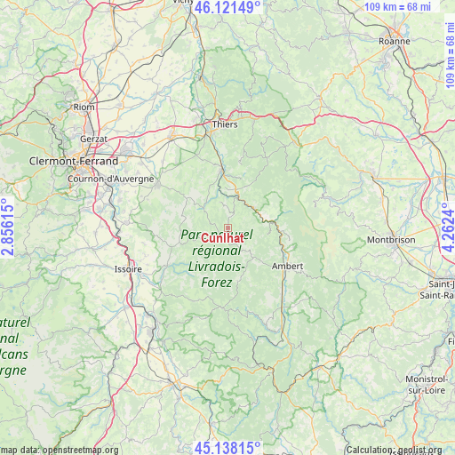
Cunlhat GPS coordinates[2]
45° 37' 55.128" North, 3° 33' 33.372" East
| Map corner | latitude | longitude |
|---|---|---|
| Upper-left | 46.12149°, | 2.85615° |
| Center: | 45.63198°, | 3.55927° |
| Lower-right: | 45.13815°, | 4.2624° |
| Map W x H: | 109.3×109.3 km | = 67.9×67.9mi |
| max Lat: | 51.07786° ⇑72.1% North |
| Cunlhat: | 45.63198° |
| min Lat: | ⇓27.9% South 41.3874° |
| min Long | Cunlhat | max Long |
| -5.08615° | 3.55927° | 9.52242° |
| W 64.8%⇐ | ⇒35.2% E |
Elevation
Elevation of Cunlhat is 724 m = 2375 ft, and this is 530.3 m = 1740 ft above average elevation for this country.
| Max E: |
2333 m = 7654 ft | 3% |
| Cunlhat | 724 m 2375 ft | |
| Avg. | 193.7 m = 635 ft | |
Min E: |
-1 m = -3 ft | 97% |
See also: France elevation on elevation.city.
Geographical zone
Cunlhat is located in North temperate zone (between Tropic of Cancer and the Arctic Circle). Distance of this North polar circle is 2327.4 km =1446.2 mi to North.| Distance of | km | miles | from Cunlhat |
|---|---|---|---|
| North Pole | 4933.3 | 3065.4 | to North |
| Arctic Circle | 2327.4 | 1446.2 | to North |
| Tropic Cancer | 2467.9 | 1533.5 | to South |
| Equator | 5073.8 | 3152.7 | to South |


Nearby cities:
15 places around Cunlhat: (largest is in red/bold)
• Augerolles
11 km =6.8 mi,  23°
23°
• Bertignat
9.6 km =6 mi,  99°
99°
• Courpière
14 km =8.7 mi,  354°
354°
• Fournols
13 km =8.1 mi,  169°
169°
• Job
14.6 km =9.1 mi, 96°
• Marat
10.1 km =6.3 mi,  72°
72°
• Montaigut
8.8 km =5.5 mi,  257°
257°
• Olliergues
7.7 km =4.8 mi,  51°
51°
• Saint-Amant-Roche-Savine
8.4 km =5.2 mi,  137°
137°
• Saint-Dier-d’Auvergne
7.7 km =4.8 mi,  309°
309°
• Saint-Ferréol-des-Côtes
16.3 km =10.1 mi,  134°
134°
• Sermentizon
15.2 km =9.4 mi,  342°
342°
• Sugères
12.2 km =7.6 mi,  254°
254°
• Tours-sur-Meymont
4.6 km =2.9 mi, 16°
• Vertolaye
11.7 km =7.3 mi,  80°
80°
Sources, notices
• [Note1] Compared only with cities in France existing in our database
• [Src1] Map data: © OpenStreetMap contributors (CC-BY-SA)
• [Src2] Other city data from geonames.org with taken over terms of usage.
• [Src3] Geographical zone / Annual Mean Temperature by Robert A. Rohde @ Wikipedia
